IMAGES TAKEN NEAR TO
Montgomery Hill, WIRRAL, CH48 1NF
Introduction
This page details the photographs taken nearby to Montgomery Hill, CH48 1NF by members of the Geograph project.
The Geograph project started in 2005 with the aim of publishing, organising and preserving representative images for every square kilometre of Great Britain, Ireland and the Isle of Man.

There are currently over 7.5m images from over14,400 individuals and you can help contribute to the project by visiting https://www.geograph.org.uk
Image Map
Images are licensed for reuse under creativecommons.org/licenses/by-sa/2.0
Notes
- Clicking on the map will re-center to the selected point.
- The higher the marker number, the further away the image location is from the centre of the postcode.
Image Listing (20 Images Found)
Images are licensed for reuse under creativecommons.org/licenses/by-sa/2.0
Image
Details
Distance
1
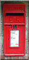
Elizabeth II postbox on Montgomery Hill
Postbox No. CH48 348.
Image: © JThomas
Taken: 25 May 2019
0.06 miles
2
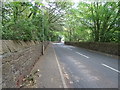
Montgomery Hill (B5140)
Looking north east beside Royden Park.
Image: © JThomas
Taken: 25 May 2019
0.07 miles
3
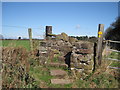
Sandstone Stile
A sandstone stile on the footpath from Grange Cross Lane to Birch Heys.
Image: © Sue Adair
Taken: 4 Apr 2010
0.11 miles
4
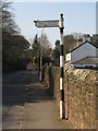
Old Direction Sign - Signpost by the B5140, Royden Park, Frankby
Ball finial - 1 arm; Wirral Footpath post by the B5140, in parish of Hoylake (Wirral District), Frankby.
Surveyed
Milestone Society National ID: CH_SJ2486.
Image: © Milestone Society
Taken: Unknown
0.14 miles
5
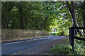
Montgomery Hill, Frankby
At the crest of the hill, from across the road, the gate to the right is signposted "Public footpath to Thurstaston".
Image: © El Pollock
Taken: 25 Mar 2012
0.15 miles
6
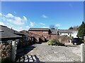
Former farm buildings at Birch Hey Farm
Former early 18th cenrury farm buildings at Birch Hey Farm, converted to desirable residential properties in the 1980's.
Image: © Sue Adair
Taken: 6 Apr 2021
0.15 miles
8
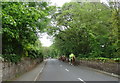
Horses on Montgomery Hill (B5140)
Looking north east.
Image: © JThomas
Taken: 25 May 2019
0.20 miles
10
National Trust boundary stone (3) on Thurstaston Common
Thurstaston Common has changed hands many times over the years, becoming Thurstaston Common Recreation Grounds in 1883, and there are a number of interesting boundary stones to be discovered around the area. Areas of the common were donated to the National Trust between 1916 and 1925, and the low stone seen here at the base of the tree is inscribed 'NT' indicating the boundary of the National Trust land. See also Image Today Thurstaston Common is jointly owned by Wirral Borough Council and The National Trust, and is managed by Wirral Rangers.
Image: © John S Turner
Taken: 21 Jan 2019
0.21 miles