IMAGES TAKEN NEAR TO
Croft Drive East, WIRRAL, CH48 1LR
Introduction
This page details the photographs taken nearby to Croft Drive East, CH48 1LR by members of the Geograph project.
The Geograph project started in 2005 with the aim of publishing, organising and preserving representative images for every square kilometre of Great Britain, Ireland and the Isle of Man.

There are currently over 7.5m images from over14,400 individuals and you can help contribute to the project by visiting https://www.geograph.org.uk
Image Map
Images are licensed for reuse under creativecommons.org/licenses/by-sa/2.0
Notes
- Clicking on the map will re-center to the selected point.
- The higher the marker number, the further away the image location is from the centre of the postcode.
Image Listing (3 Images Found)
Images are licensed for reuse under creativecommons.org/licenses/by-sa/2.0
Image
Details
Distance
1
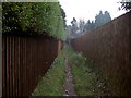
Link footpath near Caldy
A short path that links the B5140 with a cul-de-sac.
Image: © David Quinn
Taken: 22 Dec 2007
0.13 miles
2

Roundabout at Caldy crossroads
Taken from the direction of West Kirby and looking towards Heswall on the A540. Turn left for Montgomery Hill and right for Caldy, both on the B5140.
Image: © Peter Miller
Taken: 29 Aug 2005
0.18 miles
3
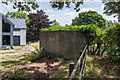
WWII Cheshire: Defences of the Wirral, Caldy Road pillbox
-
Pillbox: DoB ID: S0013837
A hexagonal pillbox in a private garden off Caldy Road (B5140). It covered the crossroads 130 yards East.
Image
Image: © Mike Searle
Taken: 25 Jul 2018
0.21 miles