IMAGES TAKEN NEAR TO
Vincent Drive, CHESTER, CH4 7RQ
Introduction
This page details the photographs taken nearby to Vincent Drive, CH4 7RQ by members of the Geograph project.
The Geograph project started in 2005 with the aim of publishing, organising and preserving representative images for every square kilometre of Great Britain, Ireland and the Isle of Man.

There are currently over 7.5m images from over14,400 individuals and you can help contribute to the project by visiting https://www.geograph.org.uk
Image Map
Images are licensed for reuse under creativecommons.org/licenses/by-sa/2.0
Notes
- Clicking on the map will re-center to the selected point.
- The higher the marker number, the further away the image location is from the centre of the postcode.
Image Listing (10 Images Found)
Images are licensed for reuse under creativecommons.org/licenses/by-sa/2.0
Image
Details
Distance
1
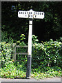
Old Milepost in Wrexham Road, Chester - Chester Cross 1 Mile
Cast iron post by the UC road, in parish of CHESTER (CHESTER District), Wrexham Road, North of drive to Grosvenor Nuffield Hospital, 300m South of Overleigh Roundabout, on pavement on East side of road. Chester Cross iron plate & post, erected by the County Council in the 19th century.
Inscription reads:-
CHESTER CROSS
1 MILE
Maker:-
: R T SMITH & CO / WHITCHURCH :
Grade II Listed.
List Entry Number: 1375989 https://historicengland.org.uk/listing/the-list/list-entry/1375989
Milestone Society National ID: CH_CHWX01
Image: © John S Turner
Taken: 16 Jul 2007
0.13 miles
2
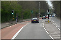
Pedestrian Controlled Traffic Lights on Wrexham Road
The A483 at Handbridge, Chester.
Image: © David Dixon
Taken: 15 Apr 2016
0.14 miles
3
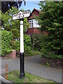
Old Milepost in Lache Lane, Chester
Cast iron post by the UC road, in parish of Chester (Chester District), Lache Lane; by drive to No. 7; 300m South West of Overleigh Roundabout, on grass between road and footpath, on East side of road. Chester Cross iron plate and post, erected by the County Council in the 19th century.
Inscription reads:-
CHESTER CROSS
1 MILE
Maker:-
: R T SMITH & CO / WHITCHURCH :
Grade II listed.
List Entry Number: 1375859 https://historicengland.org.uk/listing/the-list/list-entry/1375859
Milestone Society National ID: CH_CHXY01
Image: © A Rosevear
Taken: 30 May 2004
0.16 miles
4
Chester Approach near Handbridge
The Chester Approach (also known as the Duke's Drive), is one of a number of approaches to Eaton Hall. Chester Approach bypasses the village of Eccleston, passing through Eccleston Hill towards the hall.
Image: © Jeff Buck
Taken: 11 Aug 2014
0.18 miles
5
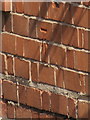
Bench mark on Eaton Park View, Wrexham Road
This Ordnance Survey bench mark is on the south east corner of Eaton Park View, Wrexham Road. It is just visible from the main road.
Image: © John S Turner
Taken: 26 Jul 2018
0.19 miles
6
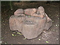
King of the woods
This wooden sculpture is located on the Dukes Drive, it is inscribed 'King of the Woods'
Image: © BrianPritchard
Taken: 5 May 2008
0.20 miles
7
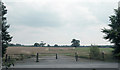
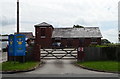
Wrexham Road farmland
A small part of the Duke of Westminster's Eaton estate.
Image: © Dennis Turner
Taken: 18 Aug 2005
0.21 miles
8
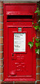
Elizabeth II postbox on Wrexham Road, Chester
Postbox No. CH4 140.
Image: © JThomas
Taken: 25 May 2019
0.22 miles
10
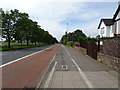
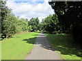
Dual use path beside Wrexham Road (A483)
Looking south west.
Image: © JThomas
Taken: 25 May 2019
0.24 miles