IMAGES TAKEN NEAR TO
Lache Lane, CHESTER, CH4 7LP
Introduction
This page details the photographs taken nearby to Lache Lane, CH4 7LP by members of the Geograph project.
The Geograph project started in 2005 with the aim of publishing, organising and preserving representative images for every square kilometre of Great Britain, Ireland and the Isle of Man.

There are currently over 7.5m images from over14,400 individuals and you can help contribute to the project by visiting https://www.geograph.org.uk
Image Map
Images are licensed for reuse under creativecommons.org/licenses/by-sa/2.0
Notes
- Clicking on the map will re-center to the selected point.
- The higher the marker number, the further away the image location is from the centre of the postcode.
Image Listing (9 Images Found)
Images are licensed for reuse under creativecommons.org/licenses/by-sa/2.0
Image
Details
Distance
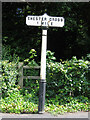
1
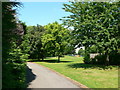
Westminster Park
The park in the suburb of the same name in the west of Chester. Also known as Wezzie Park.
Image: © Eirian Evans
Taken: 4 Jun 2008
0.17 miles
2
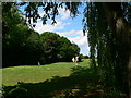
Westminster Park
Part of the 9-hole golf course in Westminster Park.
Image: © Eirian Evans
Taken: 4 Jun 2008
0.17 miles
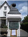
3
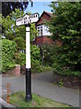
Old Milepost in Lache Lane, Chester
Cast iron post by the UC road, in parish of Chester (Chester District), Lache Lane; by drive to No. 7; 300m South West of Overleigh Roundabout, on grass between road and footpath, on East side of road. Chester Cross iron plate and post, erected by the County Council in the 19th century.
Inscription reads:-
CHESTER CROSS
1 MILE
Maker:-
: R T SMITH & CO / WHITCHURCH :
Grade II listed.
List Entry Number: 1375859 https://historicengland.org.uk/listing/the-list/list-entry/1375859
Milestone Society National ID: CH_CHXY01
Image: © A Rosevear
Taken: 30 May 2004
0.18 miles
4
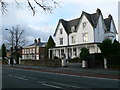
Chester Youth Hostel
A large Victorian house, built in 1856, now houses a youth hostel. It is on Hough Green.
Image: © Eirian Evans
Taken: 7 Dec 2007
0.23 miles
5
Old Milepost in Wrexham Road, Chester - Chester Cross 1 Mile
Cast iron post by the UC road, in parish of CHESTER (CHESTER District), Wrexham Road, North of drive to Grosvenor Nuffield Hospital, 300m South of Overleigh Roundabout, on pavement on East side of road. Chester Cross iron plate & post, erected by the County Council in the 19th century.
Inscription reads:-
CHESTER CROSS
1 MILE
Maker:-
: R T SMITH & CO / WHITCHURCH :
Grade II Listed.
List Entry Number: 1375989 https://historicengland.org.uk/listing/the-list/list-entry/1375989
Milestone Society National ID: CH_CHWX01
Image: © John S Turner
Taken: 16 Jul 2007
0.24 miles
6
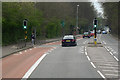
Pedestrian Controlled Traffic Lights on Wrexham Road
The A483 at Handbridge, Chester.
Image: © David Dixon
Taken: 15 Apr 2016
0.24 miles
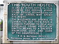
7
Chester Youth Hostel plaque 2009
In July 2009, on one of the impressive gateposts to Chester Youth Hostel, the juxtaposition of the old high-minded plaque, with the gaffer-taped planning application below, boded ill for the hostel. Citing the excessive cost of upgrading as the reason for disposal, in September 2009 the hostel has been sold and the plaque removed. The YHA website now states that there is alternative accommodation at "...YHA Liverpool (25 miles) or YHA Manchester (41 miles)"!
Regarding the youth hostels the plaque stated that:
"...they have a common purpose: to help all, especially young people of limited means..."
Image: © John S Turner
Taken: 6 Jul 2009
0.24 miles
8
Chester Youth Hostel Plaque - close up
A close up the old plaque on the gatepost of the old Chester Youth Hostel. Citing the excessive cost of upgrading as the reason for disposal, in September 2009 the hostel has been sold and the plaque removed. The YHA website now states that there is alternative accommodation at "...YHA Liverpool (25 miles) or YHA Manchester (41 miles)"!
Regarding the youth hostels the plaque stated that:
"...they have a common purpose: to help all, especially young people of limited means..."
Image: © John S Turner
Taken: 23 Apr 2008
0.24 miles
9
Hough Green away from Chester
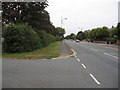
Looking along Hough Green in the direction of Saltney. The road to the left, also known as Hough Green, accesses a row of 1970s houses. The large hedge on the left does not have a bank or associated ditch, but whether it be new or old it follows the old hedge line shown on the 19th century maps. Somewhere near the lamppost there was once a First Geodetic Levelling bench mark on a stone over a gully, but there is no sign of it now, and in fact it is not shown after 1874 on any map that I have seen.
Image: © John S Turner
Taken: 18 Sep 2009
0.25 miles