IMAGES TAKEN NEAR TO
Ebury Place, CHESTER, CH4 7JW
Introduction
This page details the photographs taken nearby to Ebury Place, CH4 7JW by members of the Geograph project.
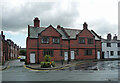
The Geograph project started in 2005 with the aim of publishing, organising and preserving representative images for every square kilometre of Great Britain, Ireland and the Isle of Man.

There are currently over 7.5m images from over14,400 individuals and you can help contribute to the project by visiting https://www.geograph.org.uk
Image Map
Images are licensed for reuse under creativecommons.org/licenses/by-sa/2.0
Notes
- Clicking on the map will re-center to the selected point.
- The higher the marker number, the further away the image location is from the centre of the postcode.
Image Listing (541 Images Found)
Images are licensed for reuse under creativecommons.org/licenses/by-sa/2.0
Image
Details
Distance
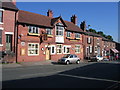
1
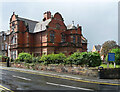
65-67 Eaton Road, Chester
Eaton estate houses by John Douglas, 1899. Grade II listed.
Image: © Stephen Richards
Taken: 19 Aug 2014
0.02 miles
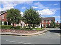
2
Paradise in Handbridge
A cul-de-sac near Queen's Park, Handbridge, puts these houses in Paradise.
Image: © Eirian Evans
Taken: 21 Apr 2007
0.03 miles
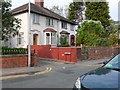
3
Belgrave Place, Handbridge
Modern housing just off the main road through Handbridge.
Image: © John S Turner
Taken: 14 Jul 2007
0.03 miles
4
Handbridge in Handbridge
Formerly The White Horse this old hostelry has now been modernised and is called 'Handbridge'. It faces the road called Handbridge, and is in the village called Handbridge. http://www.handbridge.org.uk/
Image: © John S Turner
Taken: 4 Jun 2008
0.03 miles
5
1 Overleigh Road, Chester
Multi-gabled and finialed. By Thomas Lockwood, 1895. Grade II listed.
It was a working men's institute and boys' club. The board outside reads, "Chester Youth Club", but it may now be in residential use.
Image: © Stephen Richards
Taken: 19 Aug 2014
0.04 miles
6

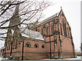
St Mary-Without-the-Walls, Overleigh Road, Chester
By F.B. Wade, 1885-87, for the 1st Duke of Westminster. Grade II* listed.
In front is an estate cottage, by Douglas & Fordham, 1887-88. It has a shaped gable and a quartet of twisted chimneys. Grade II listed.
Image: © Stephen Richards
Taken: 19 Aug 2014
0.05 miles
7
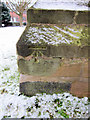
Bench mark on St Mary Without the Walls
This bench mark is on the buttress at the southeast corner of the church. http://www.bench-marks.org.uk/bm27904
Image: © John S Turner
Taken: 18 Dec 2010
0.05 miles
8
St Mary Without the Walls
This church was built in 1887 to replace St Mary on the Hill, which was closed at the same time, and is within the city walls.
Image: © John S Turner
Taken: 18 Dec 2010
0.05 miles
9

St Marys without the Walls - South side door
The southern side gate and door to St Mary without the Walls in Handbridge, as seen from Overleigh Road.
Image: © John S Turner
Taken: 24 Oct 2007
0.05 miles
10
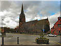
St Mary's Church
The Parish Church of St Mary Without-the-Walls is situated on Overleigh Road in Handbridge, south of the River Dee. The present church was built in 1887.
Image: © David Dixon
Taken: 9 Nov 2010
0.06 miles