IMAGES TAKEN NEAR TO
Roman Crescent, CHESTER, CH4 7DQ
Introduction
This page details the photographs taken nearby to Roman Crescent, CH4 7DQ by members of the Geograph project.
The Geograph project started in 2005 with the aim of publishing, organising and preserving representative images for every square kilometre of Great Britain, Ireland and the Isle of Man.

There are currently over 7.5m images from over14,400 individuals and you can help contribute to the project by visiting https://www.geograph.org.uk
Image Map
Images are licensed for reuse under creativecommons.org/licenses/by-sa/2.0
Notes
- Clicking on the map will re-center to the selected point.
- The higher the marker number, the further away the image location is from the centre of the postcode.
Image Listing (10 Images Found)
Images are licensed for reuse under creativecommons.org/licenses/by-sa/2.0
Image
Details
Distance
1
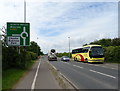
Wrexham Road (A483) approaching roundabout
Looking south west.
Image: © JThomas
Taken: 25 May 2019
0.16 miles

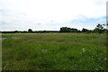
4
Rowcliffe Avenue, Lache
Wikipedia http://en.wikipedia.org/wiki/Lache
Image: © Jeff Buck
Taken: 24 Feb 2014
0.20 miles
5
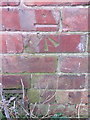
Bench mark on Fir Tree Farm house - 12 Feb 2016
This Ordnance Survey bench mark was cut into the north east face of Fir Tree Farm house, next to the A483 Wrexham Road, outside Chester - Image] The farm house had been abandoned for many years and was demolished sometime in 2018 - Image
Image: © John S Turner
Taken: 12 Feb 2016
0.20 miles
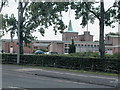
6
Offices at Chester Business Park
Office buildings known locally as 'Tenko Buildings' due to their design. Standing in the Chester Business Park near to the A55
Image: © Dot Potter
Taken: 14 Aug 2005
0.20 miles
7
The King's School Chester
Founded by Henry VIII in Chester Cathedral.
Image: © Dennis Turner
Taken: 18 Aug 2005
0.20 miles
8
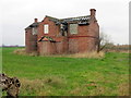
Fir Tree Farm house - 12 Feb 2016
Fir Tree Farm had been abandoned for many years and was demolished sometime in 2018 - Image There was an Ordnance Survey bench mark on the north east/right hand gable end of the house - Image
Image: © John S Turner
Taken: 12 Feb 2016
0.21 miles
9

Formerly Fir Tree Farm house
Fir Tree Farmhouse had been abandoned for many years and was demolished in 2018. See the farmhouse in 2016 Image As usual the tidy demolition site has been defaced by fly-tippers.
Image: © John S Turner
Taken: 9 Aug 2018
0.21 miles
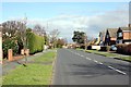
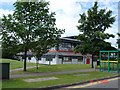
10

Westminster Park
Parade of shops serving a large residential area to the south of Chester.
Image: © Dennis Turner
Taken: 18 Aug 2005
0.24 miles