IMAGES TAKEN NEAR TO
St. Georges Crescent, CHESTER, CH4 7AR
Introduction
This page details the photographs taken nearby to St. Georges Crescent, CH4 7AR by members of the Geograph project.
The Geograph project started in 2005 with the aim of publishing, organising and preserving representative images for every square kilometre of Great Britain, Ireland and the Isle of Man.

There are currently over 7.5m images from over14,400 individuals and you can help contribute to the project by visiting https://www.geograph.org.uk
Image Map
Images are licensed for reuse under creativecommons.org/licenses/by-sa/2.0
Notes
- Clicking on the map will re-center to the selected point.
- The higher the marker number, the further away the image location is from the centre of the postcode.
Image Listing (107 Images Found)
Images are licensed for reuse under creativecommons.org/licenses/by-sa/2.0
Image
Details
Distance
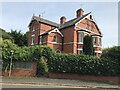
1
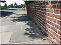
St George's Crescent, Handbridge and a bench mark
Looking west along St George's Crescent with an Ordnance Survey bench mark on the wall on the right - see Image
Image: © John S Turner
Taken: 18 May 2014
0.04 miles
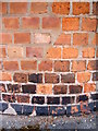
2
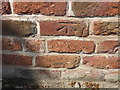
Bench mark in St Georges Crescent, Handbridge
This bench mark is on the roadside wall between #24 and #26 St George's Crescent, and has been recorded on old-maps since 1911. See also Image
Image: © John S Turner
Taken: 18 May 2014
0.05 miles
3
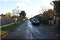
Cross Hey, Handbridge
Cross Hey from the junction with Meadows Lane.
Image: © Jeff Buck
Taken: 4 Nov 2013
0.06 miles
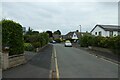
4
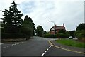
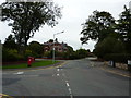
Queens Park Road
Looking along Queens Park Road at the junction with St. John's Road.
Image: © DS Pugh
Taken: 8 Aug 2020
0.10 miles

6
House on South Crescent Road, Chester
Image: © Richard Humphrey
Taken: 21 Sep 2021
0.10 miles
7
Along Andrew Crescent
Looking along Andrew Crescent in Chester.
Image: © DS Pugh
Taken: 8 Aug 2020
0.11 miles
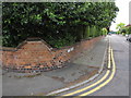
8
Bench mark on the corner of St John's Road
This bench mark is on the rounded corner of the wall where St John's Road meets Queen's Park Road. The top left part of the wall seems to have been rebuilt but the bench mark appears to be in its original place. See also Image
Image: © John S Turner
Taken: 9 Jul 2009
0.11 miles
9
The corner of St John's Road, Handbridge
The corner of St John's Road where it meets Queen's Park Road in Handbridge. On the wall in the middle of the corner there is a small bench mark - Image
Image: © John S Turner
Taken: 9 Jul 2009
0.11 miles
10
Queen's Park Road, Chester
At the junction with Victoria Crescent and South Crescent Road.
Image: © Peter Barr
Taken: 26 Sep 2013
0.11 miles