IMAGES TAKEN NEAR TO
Claverton Court, Queens Park Road, CHESTER, CH4 7AF
Introduction
This page details the photographs taken nearby to Claverton Court, Queens Park Road, CH4 7AF by members of the Geograph project.
The Geograph project started in 2005 with the aim of publishing, organising and preserving representative images for every square kilometre of Great Britain, Ireland and the Isle of Man.

There are currently over 7.5m images from over14,400 individuals and you can help contribute to the project by visiting https://www.geograph.org.uk
Image Map
Images are licensed for reuse under creativecommons.org/licenses/by-sa/2.0
Notes
- Clicking on the map will re-center to the selected point.
- The higher the marker number, the further away the image location is from the centre of the postcode.
Image Listing (546 Images Found)
Images are licensed for reuse under creativecommons.org/licenses/by-sa/2.0
Image
Details
Distance
1
Victoria Crescent, Chester
Part of the leafy suburb of Queen's Park on the south side of the River Dee.
Image: © Jaggery
Taken: 6 Oct 2013
0.06 miles
2
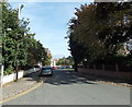
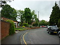
Queens Park Road
Looking along Queens Park Road at the junction with St. John's Road.
Image: © DS Pugh
Taken: 8 Aug 2020
0.06 miles
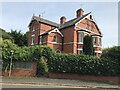
3
Junction of South Crescent Road with Victoria Crescent, Chester
Image: © Ruth Sharville
Taken: 3 Nov 2009
0.07 miles
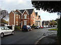
4
House on South Crescent Road, Chester
Image: © Richard Humphrey
Taken: 21 Sep 2021
0.07 miles
6
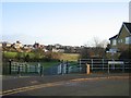
Earls Eye/The Meadows
Officially the Earls Eye (field), but generally known as the Meadows, this land was purchased by the city in 1929 with money donated by Alderman Brown. He wanted it to be an amenity for the people of Chester, which it still is today.
Image: © John S Turner
Taken: 4 Dec 2006
0.08 miles
7
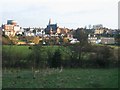
The Meadows and St Paul's, Boughton
Looking from Lower Park Road, Handbridge, across The Meadows and the River Dee to Boughton. St Paul's church, designed by the significant local architect John Douglas 1830-1911, is in the centre, and the top of the water tower can be seen at top left.
Image: © John S Turner
Taken: 4 Dec 2006
0.08 miles
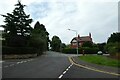
8
Queen's Park Road, Chester
At the junction with Victoria Crescent and South Crescent Road.
Image: © Peter Barr
Taken: 26 Sep 2013
0.09 miles
9
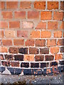
Bench mark on the corner of St John's Road
This bench mark is on the rounded corner of the wall where St John's Road meets Queen's Park Road. The top left part of the wall seems to have been rebuilt but the bench mark appears to be in its original place. See also Image
Image: © John S Turner
Taken: 9 Jul 2009
0.09 miles
10
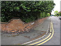
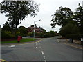
The corner of St John's Road, Handbridge
The corner of St John's Road where it meets Queen's Park Road in Handbridge. On the wall in the middle of the corner there is a small bench mark - Image
Image: © John S Turner
Taken: 9 Jul 2009
0.09 miles