IMAGES TAKEN NEAR TO
Barn Hey Crescent, WIRRAL, CH47 9RN
Introduction
This page details the photographs taken nearby to Barn Hey Crescent, CH47 9RN by members of the Geograph project.
The Geograph project started in 2005 with the aim of publishing, organising and preserving representative images for every square kilometre of Great Britain, Ireland and the Isle of Man.

There are currently over 7.5m images from over14,400 individuals and you can help contribute to the project by visiting https://www.geograph.org.uk
Image Map
Images are licensed for reuse under creativecommons.org/licenses/by-sa/2.0
Notes
- Clicking on the map will re-center to the selected point.
- The higher the marker number, the further away the image location is from the centre of the postcode.
Image Listing (11 Images Found)
Images are licensed for reuse under creativecommons.org/licenses/by-sa/2.0
Image
Details
Distance
1
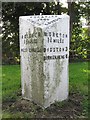
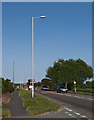
Old Milepost by the A553, south east of Meols
Cast iron post by the A553, in parish of Hoylake (Wirral District), South East of Fornall Bridge and Heron Road junction, on the verge, on South side of road. Cast iron CCC1896, erected by the County Council in the 19th century.
Inscription reads:-
: HOYLAKE / 1½ MILES / WEST KIRBY 3¼ : : CHESHIRE / 1896 / COUNTY COUNCIL : : MORETON / 1¾ MILES / BIDSTON 3 / BIRKENHEAD 6 :
Maker:-
: W H SMITH & CO / MAKERS / WHITCHURCH :
Merseyside HER.
https://www.heritagegateway.org.uk/Gateway/Results_Single.aspx?uid=3314279&resourceID=1970
Milestone Society National ID: CH_HYBK01
Image: © J Higgins
Taken: 1 Jul 2004
0.08 miles
2
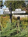
Old Direction Sign - Signpost by the A553, Fornall Bridge, Hoylake
Pawn finial - 3 arms; Cheshire CCC octagonal by the A553, Fornall Bridge in the parish of Hoylake (Wirral District).
Surveyed
Milestone Society National ID: CH_SJ2389.
Image: © Milestone Society
Taken: Unknown
0.09 miles
4
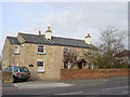
Thimble Inn House, Meols
Thimble Inn House On Birkenhead Road, Meols
Image: © Sue Adair
Taken: 18 Apr 2006
0.10 miles
5
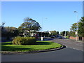
Fingerpost to Greasby, Meols
Fingerpost to Greasby, Hoylake and Moreton in centre of roundabout at the junction of Hoylake Road with Heron Lane, Meols. Note the old style red phonebox beyond.
Image: © Sue Adair
Taken: 13 Nov 2005
0.14 miles
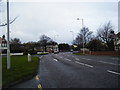
8
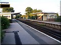
Meols Railway Station
Situated on Birkenhead Road. This is the view towards Moreton.
Image: © El Pollock
Taken: 23 Jul 2009
0.22 miles
9
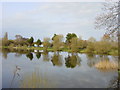
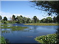
Fishing Pond, Meols
Fishing pond adjacent to Meols station from the A553.
Image: © Sue Adair
Taken: 18 Apr 2006
0.23 miles
10
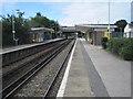
Meols railway station, Wirral
Opened in 1866 by the Hoylake Railway, later part of the Wirral Railway, on what is now the line from Liverpool to West Kirby. The station was rebuilt in 1938.
View west towards Manor Road and West Kirby.
Image: © Nigel Thompson
Taken: 7 Aug 2010
0.24 miles