IMAGES TAKEN NEAR TO
Parkway, WIRRAL, CH47 7BT
Introduction
This page details the photographs taken nearby to Parkway, CH47 7BT by members of the Geograph project.
The Geograph project started in 2005 with the aim of publishing, organising and preserving representative images for every square kilometre of Great Britain, Ireland and the Isle of Man.

There are currently over 7.5m images from over14,400 individuals and you can help contribute to the project by visiting https://www.geograph.org.uk
Image Map
Images are licensed for reuse under creativecommons.org/licenses/by-sa/2.0
Notes
- Clicking on the map will re-center to the selected point.
- The higher the marker number, the further away the image location is from the centre of the postcode.
Image Listing (23 Images Found)
Images are licensed for reuse under creativecommons.org/licenses/by-sa/2.0
Image
Details
Distance
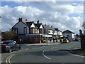
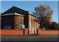
6
Churches Together
Side elevation of St. Andrews, Birkenhead Road, Meols.
Image: © J Scott
Taken: 7 Nov 2010
0.11 miles
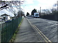
7
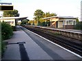
Meols Railway Station
Situated on Birkenhead Road. This is the view towards Moreton.
Image: © El Pollock
Taken: 23 Jul 2009
0.11 miles
8

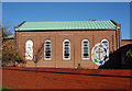
Traditional Building
Original St. Andrews church, Greenwood Road entrance.
Image: © J Scott
Taken: 7 Nov 2010
0.11 miles
9
Worship House
St. Andrews Church, Birkenhead Road (A533), Meols.
Image: © J Scott
Taken: 7 Nov 2010
0.11 miles