IMAGES TAKEN NEAR TO
Elwyn Road, WIRRAL, CH47 7AP
Introduction
This page details the photographs taken nearby to Elwyn Road, CH47 7AP by members of the Geograph project.
The Geograph project started in 2005 with the aim of publishing, organising and preserving representative images for every square kilometre of Great Britain, Ireland and the Isle of Man.

There are currently over 7.5m images from over14,400 individuals and you can help contribute to the project by visiting https://www.geograph.org.uk
Image Map
Images are licensed for reuse under creativecommons.org/licenses/by-sa/2.0
Notes
- Clicking on the map will re-center to the selected point.
- The higher the marker number, the further away the image location is from the centre of the postcode.
Image Listing (37 Images Found)
Images are licensed for reuse under creativecommons.org/licenses/by-sa/2.0
Image
Details
Distance
3
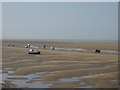
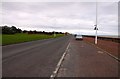
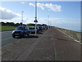
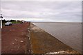
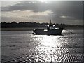
Fishing boats off Dove Point, Meols
At this point on the North Wirral Coastal Park there is once more a proper purpose built promenade as we approach Meols. There are a small number of fishing boats but now more pleasure craft.
Image: © Sue Adair
Taken: 17 Aug 2005
0.12 miles