IMAGES TAKEN NEAR TO
Birkenhead Road, WIRRAL, CH47 5AE
Introduction
This page details the photographs taken nearby to Birkenhead Road, CH47 5AE by members of the Geograph project.
The Geograph project started in 2005 with the aim of publishing, organising and preserving representative images for every square kilometre of Great Britain, Ireland and the Isle of Man.

There are currently over 7.5m images from over14,400 individuals and you can help contribute to the project by visiting https://www.geograph.org.uk
Image Map
Images are licensed for reuse under creativecommons.org/licenses/by-sa/2.0
Notes
- Clicking on the map will re-center to the selected point.
- The higher the marker number, the further away the image location is from the centre of the postcode.
Image Listing (59 Images Found)
Images are licensed for reuse under creativecommons.org/licenses/by-sa/2.0
Image
Details
Distance
1
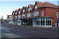
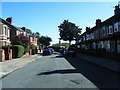
Birkenhead Road, Hoylake
A neat row of shops lines the south side of Birkenhead Road between Newton Road and Manor Road. Second from right is Maluca, a brasserie; none of the other establishments appear to be open in this Sunday lunchtime view. This is looking towards Meols (pronounced Mells).
Image: © Stephen McKay
Taken: 30 Nov 2014
0.03 miles
3
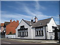
Under Development
Old Hoylake Cottage Hospital entrance corner of Deneshey Road, Birkenhead Road.
Image: © J Scott
Taken: 7 Nov 2010
0.13 miles
4
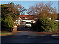
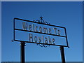
Hoylake Awaits
Welcome sign along the A533 (Birkenhead Road) at the junction with Deneshey Road.
Image: © J Scott
Taken: 7 Nov 2010
0.14 miles
6
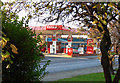
What's The Total?
Filling station opposite Hoylake Cottage Hospital, Birkenhead Road (A533), Hoylake.
Image: © J Scott
Taken: 7 Nov 2010
0.15 miles
8
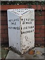
Old Milepost by the A553, Birkenhead Road, Hoylake
Cast iron post by the A553, in parish of Hoylake (Wirral District), opposite Hoylake Hospital, in paving slabs in front of brick wall, on South side of road. Cast iron CCC1896, erected by the County Council in the 19th century.
Inscription reads:-
: HOYLAKE / ½ MILE / WEST KIRBY 2¼ : : CHESHIRE / 1896 / COUNTY COUNCIL : : MORETON / 2¾ MILES / BIDSTON 4 / BIRKENHEAD 7 :
Merseyside HER.
https://www.heritagegateway.org.uk/Gateway/Results_Single.aspx?uid=3314278&resourceID=1970
Milestone Society National ID: CH_HYBK00
Image: © J Higgins
Taken: 1 Jul 2004
0.16 miles
9
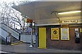
Manor Road Railway Station
Viewed from a train which is heading towards West Kirby.
Image: © El Pollock
Taken: 30 May 2012
0.18 miles
10
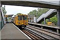
Manor Road Station, Hoylake
507032 waits to depart with a service from West Kirby to Liverpool.
Image: © El Pollock
Taken: 8 Jun 2012
0.18 miles