IMAGES TAKEN NEAR TO
Carterton Road, WIRRAL, CH47 4FD
Introduction
This page details the photographs taken nearby to Carterton Road, CH47 4FD by members of the Geograph project.
The Geograph project started in 2005 with the aim of publishing, organising and preserving representative images for every square kilometre of Great Britain, Ireland and the Isle of Man.

There are currently over 7.5m images from over14,400 individuals and you can help contribute to the project by visiting https://www.geograph.org.uk
Image Map
Images are licensed for reuse under creativecommons.org/licenses/by-sa/2.0
Notes
- Clicking on the map will re-center to the selected point.
- The higher the marker number, the further away the image location is from the centre of the postcode.
Image Listing (11 Images Found)
Images are licensed for reuse under creativecommons.org/licenses/by-sa/2.0
Image
Details
Distance
1
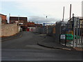
Dead End
Carsgoe Road, off Carr Lane, Carr Lane Industrial Estate,Hoylake.
Image: © J Scott
Taken: 14 Nov 2010
0.05 miles
2
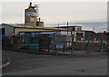
Rawell Tower
Carsgoe Road junction with Carr Lane, Carr Lane Industrial Estate, Hoylake.
Image: © J Scott
Taken: 14 Nov 2010
0.05 miles
3
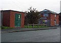
Sub Station
Substation close to junction of Carsthorne Road and Carr Lane, Carr Lane, Industrial Estate, Hoylake.
Image: © J Scott
Taken: 14 Nov 2010
0.09 miles
5
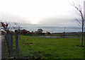
Play Time
Recreation ground adjactent to Industrial Estate, Carr Lane, Hoylake.
Image: © J Scott
Taken: 14 Nov 2010
0.13 miles
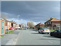
6
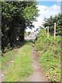
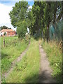
Footpath and Carr Lane
The footpath follows the old path of Carr Lane, which I think was an old road between Hoylake and Saughall Massie Road (both ends are called Carr Lane).
Image: © David Quinn
Taken: 24 Jul 2009
0.14 miles
8
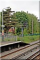
Signal, Manor Road Station, Hoylake
Signal number ML593, situated at the end of the West Kirby-bound platform.
Image: © El Pollock
Taken: 8 Jun 2012
0.22 miles
9
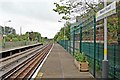
Manor Road Station, Hoylake
Looking towards West Kirby, from the Liverpool-bound platform.
Image: © El Pollock
Taken: 8 Jun 2012
0.22 miles
10
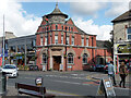
52 Market Street, Hoylake
Built for the Bank of Liverpool in 1904-05 by Willink & Thicknesse. Grade II listed.
It is/was Bank Coffee Shop.
Image: © Stephen Richards
Taken: 22 Aug 2014
0.24 miles