IMAGES TAKEN NEAR TO
Government Road, WIRRAL, CH47 2DQ
Introduction
This page details the photographs taken nearby to Government Road, CH47 2DQ by members of the Geograph project.
The Geograph project started in 2005 with the aim of publishing, organising and preserving representative images for every square kilometre of Great Britain, Ireland and the Isle of Man.

There are currently over 7.5m images from over14,400 individuals and you can help contribute to the project by visiting https://www.geograph.org.uk
Image Map
Images are licensed for reuse under creativecommons.org/licenses/by-sa/2.0
Notes
- Clicking on the map will re-center to the selected point.
- The higher the marker number, the further away the image location is from the centre of the postcode.
Image Listing (38 Images Found)
Images are licensed for reuse under creativecommons.org/licenses/by-sa/2.0
Image
Details
Distance
1
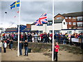
Hoylake Sailing Club
When the sailing club on Hoylake Promenade was founded in 1887 it was possible to launch boats and sail immediately in front of the clubhouse. Now, due to lack of water caused by sand deposition, sailing takes place farther along the promenade or offshore and is only possible inshore immediately off the clubhouse on the very highest spring tides. The abundance of sand is a boon to sand-yachters, here raising the flags in the opening ceremony of the 2007 European Sandyacht Championship.
Image: © John Hughes
Taken: 16 Sep 2007
0.01 miles
2
Hoylake Sailing Club
Founded in 1887 on Hoylake Promenade. At that time, it was possible to sail just in front of the clubhouse but this is no longer possible because of sand deposition.
Image: © Eirian Evans
Taken: 12 Sep 2009
0.03 miles
3
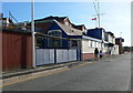
Hoylake Lifeboat Museum (closed)
The old lifeboat station on the North Parade at Hoylake became a museum after the new lifeboat station was opened in November 2008. Sadly, the museum closed in April 2015 due to problems in securing funding.
Image: © Jeff Buck
Taken: 25 Jan 2017
0.05 miles
4
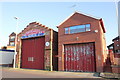
Hoylake Lifeboat Station
Hoylake Lifeboat Station with the Lady Of Hilbre lifeboat which was named by His Royal Highness The Duke of Kent, President of the RNLI, in 1991. Hoylake lifeboat station was established by the Liverpool Docks Committee in 1803 and is one of the oldest stations. A new, state of the art station is nearing completion, just along the promenade, it can be viewed on the website below.
http://www.hoylakelifeboat.org.uk/
Image: © Sue Adair
Taken: 21 Jul 2008
0.05 miles
6
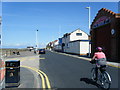
The North Parade at Hoylake
Heading north east along the North Parade at Hoylake, also part of the Wirral Circular Trail.
Wikipedia https://en.wikipedia.org/wiki/Hoylake
Image: © Jeff Buck
Taken: 25 Jan 2017
0.07 miles
7
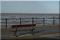
Hoylake Beach
Looking out over the flat sands with an offshore wind farm in the distance.
Image: © Stephen McKay
Taken: 30 Nov 2014
0.07 miles
8
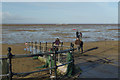
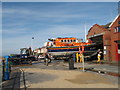
Hoylake Beach
This slipway is immediately opposite the old lifeboat station which has been replaced by a newer one a little further north-east. Out on the sands are two RNLI launch and recovery vehicles which will handle the new Shannon class lifeboat which was due to be delivered the following day. They make a deafening roar even at this distance.
Image: © Stephen McKay
Taken: 30 Nov 2014
0.07 miles
9
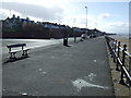
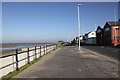
Promenade and coastal path, Hoylake
Heading south west.
Image: © JThomas
Taken: 1 Mar 2014
0.08 miles
10
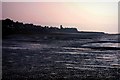
Hoylake Beach at Dusk
With Hilbre Point and Red Rocks in the background.
Image: © Stephen Nunney
Taken: Unknown
0.08 miles