IMAGES TAKEN NEAR TO
Stanley Road, WIRRAL, CH47 1HY
Introduction
This page details the photographs taken nearby to Stanley Road, CH47 1HY by members of the Geograph project.
The Geograph project started in 2005 with the aim of publishing, organising and preserving representative images for every square kilometre of Great Britain, Ireland and the Isle of Man.

There are currently over 7.5m images from over14,400 individuals and you can help contribute to the project by visiting https://www.geograph.org.uk
Image Map
Images are licensed for reuse under creativecommons.org/licenses/by-sa/2.0
Notes
- Clicking on the map will re-center to the selected point.
- The higher the marker number, the further away the image location is from the centre of the postcode.
Image Listing (16 Images Found)
Images are licensed for reuse under creativecommons.org/licenses/by-sa/2.0
Image
Details
Distance
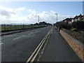
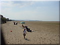
3
Beach Road, Hoylake
Heading south towards Stanley Road.
Image: © JThomas
Taken: 1 Mar 2014
0.12 miles
6
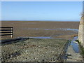
The end of Beach Road
Slipway onto the sands, Hoylake.
Image: © JThomas
Taken: 1 Mar 2014
0.15 miles
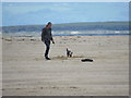
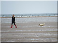
7
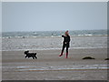
Beach at Hoylake
Beach at Hoylake looking towards Hilbre Island
Image: © Sue Adair
Taken: 17 Aug 2005
0.16 miles
8

The Dee Estuary from the air
Hoylake is in the foreground, Wales disappears in the distance under a blanket of clouds. Viewed from a Glasgow to Bristol easyJet flight.
Image: © Thomas Nugent
Taken: 3 May 2010
0.17 miles
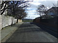
9
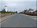
Staney Road, Hoylake
Looking up Stanley Road from beach.
Image: © chris croft
Taken: 14 Apr 2009
0.19 miles
10
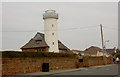
Replica lighthouse on private house
At the end of Stanley Road is this replica private lighthouse.
Image: © Steve Fareham
Taken: 7 Oct 2007
0.20 miles