IMAGES TAKEN NEAR TO
The Royal, WIRRAL, CH47 1HS
Introduction
This page details the photographs taken nearby to The Royal, CH47 1HS by members of the Geograph project.
The Geograph project started in 2005 with the aim of publishing, organising and preserving representative images for every square kilometre of Great Britain, Ireland and the Isle of Man.

There are currently over 7.5m images from over14,400 individuals and you can help contribute to the project by visiting https://www.geograph.org.uk
Image Map
Images are licensed for reuse under creativecommons.org/licenses/by-sa/2.0
Notes
- Clicking on the map will re-center to the selected point.
- The higher the marker number, the further away the image location is from the centre of the postcode.
Image Listing (14 Images Found)
Images are licensed for reuse under creativecommons.org/licenses/by-sa/2.0
Image
Details
Distance
2
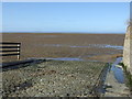
The end of Beach Road
Slipway onto the sands, Hoylake.
Image: © JThomas
Taken: 1 Mar 2014
0.04 miles
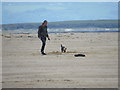
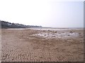
3
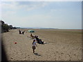
Beach at Hoylake
Beach at Hoylake looking towards Hilbre Island
Image: © Sue Adair
Taken: 17 Aug 2005
0.05 miles
4
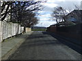
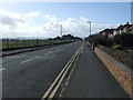
Beach Road, Hoylake
Heading south towards Stanley Road.
Image: © JThomas
Taken: 1 Mar 2014
0.05 miles
8
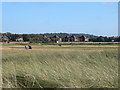
Royal Liverpool Golf Club
Not at Liverpool, but on the Wirral at Hoylake .It was built in 1869, on what was then the racecourse of the Liverpool Hunt Club, and is the oldest of all the English seaside courses with the exception of Westward Ho! in Devon.
Image: © Eirian Evans
Taken: 12 Sep 2009
0.16 miles
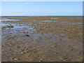
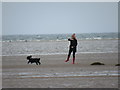
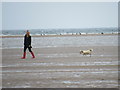
10
The tidal beach off Hoylake
Hilbre Island seen on horizon
Image: © Raymond Knapman
Taken: 22 Mar 2012
0.20 miles