IMAGES TAKEN NEAR TO
Queens Avenue, WIRRAL, CH47 0LX
Introduction
This page details the photographs taken nearby to Queens Avenue, CH47 0LX by members of the Geograph project.
The Geograph project started in 2005 with the aim of publishing, organising and preserving representative images for every square kilometre of Great Britain, Ireland and the Isle of Man.

There are currently over 7.5m images from over14,400 individuals and you can help contribute to the project by visiting https://www.geograph.org.uk
Image Map
Images are licensed for reuse under creativecommons.org/licenses/by-sa/2.0
Notes
- Clicking on the map will re-center to the selected point.
- The higher the marker number, the further away the image location is from the centre of the postcode.
Image Listing (23 Images Found)
Images are licensed for reuse under creativecommons.org/licenses/by-sa/2.0
Image
Details
Distance
2
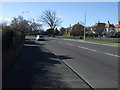
Birkenhead Road (A553)
Heading south west towards West Kirby.
Image: © JThomas
Taken: 1 Mar 2014
0.17 miles
3
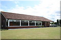
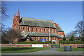
The New Meols Club All Weather Veranda Extension
The Mayor and Mayoress of Wirral, Andrew and Kathy Hodgson officially opened Great Meols Bowling Club extension on 3rd August 2009. Local community fundraiser and member of the club Roy Shuttleworth raised the funds for the much needed extension. The bowling club is a jewel in the community has over 250 active members. The extension allows friends, family and visiting guests to watch the game in a sheltered environment.
Image: © Roy James Shuttleworth
Taken: 26 Jul 2009
0.17 miles
4
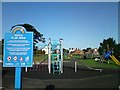
The New Meols Park Play Area
The Meols Park Play Area Has been refurbished after a campaign from the newly formed community group 'Friends of Meols Park' The group was formed in October 2007 and the project was completed successfully and the play area opened on the 1st July 2009. For more details see website www.friendsofmeolspark.co.uk
Image: © Roy James Shuttleworth
Taken: 6 Aug 2009
0.17 miles
5
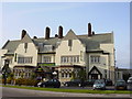
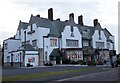
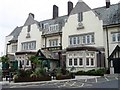
The Railway, Meols
The Railway, a large public house on Birkenhead Road, Meols, built in 1937.
Image: © Sue Adair
Taken: 18 Apr 2006
0.19 miles
6
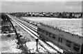
Heading to West Kirby ? 1970
Looking west from the bridge at Meols Station. This is one of the postwar (1956) units, later classified by British Rail as Class 503. The field on the right has since been developed as housing.
Image: © Alan Murray-Rust
Taken: 7 Mar 1970
0.19 miles