IMAGES TAKEN NEAR TO
Fender Lane, WIRRAL, CH46 9PA
Introduction
This page details the photographs taken nearby to Fender Lane, CH46 9PA by members of the Geograph project.
The Geograph project started in 2005 with the aim of publishing, organising and preserving representative images for every square kilometre of Great Britain, Ireland and the Isle of Man.

There are currently over 7.5m images from over14,400 individuals and you can help contribute to the project by visiting https://www.geograph.org.uk
Image Map (Loading...)


Getting Data...Please wait
Leaflet Map data © OpenStreetMap
Images are licensed for reuse under creativecommons.org/licenses/by-sa/2.0
Notes
- Clicking on the map will re-center to the selected point.
- The higher the marker number, the further away the image location is from the centre of the postcode.
Image Listing (9 Images Found)
Images are licensed for reuse under creativecommons.org/licenses/by-sa/2.0
Image
Details
Distance
1
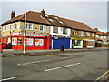
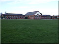
Shops on Reeds Lane
Located opposite the primary school close to the junction with Fender Lane.
Image: © David Quinn
Taken: 5 Jan 2008
0.08 miles
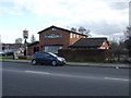
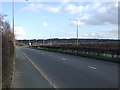
3
Pub to let
If you could handle spending your working life in an armchair
Image: © Ian Greig
Taken: 16 Jun 2017
0.12 miles
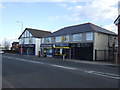
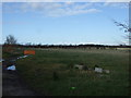
5
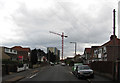
Stavordale Road, Moreton
Stavordale Road, Moreton, with ongoing demolition of high rise flats visible in the distance.
Image: © William Starkey
Taken: 17 Mar 2013
0.15 miles