IMAGES TAKEN NEAR TO
Lingham Close, WIRRAL, CH46 7UL
Introduction
This page details the photographs taken nearby to Lingham Close, CH46 7UL by members of the Geograph project.
The Geograph project started in 2005 with the aim of publishing, organising and preserving representative images for every square kilometre of Great Britain, Ireland and the Isle of Man.

There are currently over 7.5m images from over14,400 individuals and you can help contribute to the project by visiting https://www.geograph.org.uk
Image Map (Loading...)


Getting Data...Please wait
Leaflet Map data © OpenStreetMap
Images are licensed for reuse under creativecommons.org/licenses/by-sa/2.0
Notes
- Clicking on the map will re-center to the selected point.
- The higher the marker number, the further away the image location is from the centre of the postcode.
Image Listing (5 Images Found)
Images are licensed for reuse under creativecommons.org/licenses/by-sa/2.0
Image
Details
Distance
1
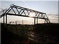
Footbridge, Lingham Lane, Moreton
The footbridge crosses over the railway line between Moreton & Meols.
Image: © El Pollock
Taken: 24 Jul 2009
0.09 miles
2
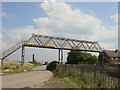
Footbridge, Lingham Lane, Moreton
Footbridge across the Merseyrail West Kirby to Liverpool line at Lingham Lane, Moreton.
Image: © Sue Adair
Taken: 17 Aug 2005
0.12 miles
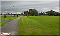
4
Dan Tec
Continuation of Tarran Way South on the Moreton Industrial estate.
Image: © J Scott
Taken: 14 Nov 2010
0.21 miles
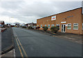
5
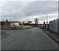
Only one way
Tarran Way South is the One way entrance road to the Moreton Industrial estate.
Image: © J Scott
Taken: 14 Nov 2010
0.25 miles