IMAGES TAKEN NEAR TO
Silverburn Avenue, WIRRAL, CH46 7TJ
Introduction
This page details the photographs taken nearby to Silverburn Avenue, CH46 7TJ by members of the Geograph project.
The Geograph project started in 2005 with the aim of publishing, organising and preserving representative images for every square kilometre of Great Britain, Ireland and the Isle of Man.

There are currently over 7.5m images from over14,400 individuals and you can help contribute to the project by visiting https://www.geograph.org.uk
Image Map (Loading...)


Getting Data...Please wait
Leaflet Map data © OpenStreetMap
Images are licensed for reuse under creativecommons.org/licenses/by-sa/2.0
Notes
- Clicking on the map will re-center to the selected point.
- The higher the marker number, the further away the image location is from the centre of the postcode.
Image Listing (25 Images Found)
Images are licensed for reuse under creativecommons.org/licenses/by-sa/2.0
Image
Details
Distance
1
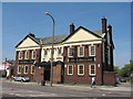
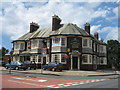
The Plough Inn
Dating from the 17th century, it is the oldest of the three main public houses in Moreton and was originally named the Plough Inn and the Druids Arms. In the early 1930's it became known simply as the Plough Inn.
Image: © Sue Adair
Taken: 6 May 2008
0.04 miles
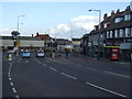
3
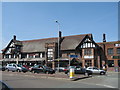
Coach and Horses
The big, bold pub by the busy roundabout that is a bit of a landmark. The youngest of the three public houses in the village, the Coach and Horses dates from the early 1800's, the original building having been knocked down and replaced in 1928.
Image: © Sue Adair
Taken: 6 May 2008
0.07 miles
4
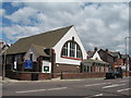
Moreton Presbyterian Church
Moreton Presbyterian Church on Hoylake Road.
Image: © Sue Adair
Taken: 16 Jul 2007
0.07 miles
5
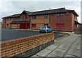
Centre of health
Pasture Road Health Centre, Moreton.
Image: © J Scott
Taken: 14 Nov 2010
0.07 miles
6
God Is Love
Old Marylands Lane entrance to Moreton Christian Assembly.
Image: © J Scott
Taken: 14 Nov 2010
0.09 miles
8
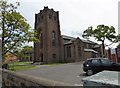
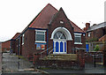
Sacred Heart Parish Centre, Moreton
Roman Catholic church in the heart of the village
Image: © Eirian Evans
Taken: 17 May 2016
0.10 miles
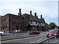
9
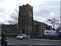
The Farmers Arms, Moreton
The Farmers Arms public house in Barnston Lane, Moreton dates from the late 1700's and even in the early 1900's, parts were still being used as a farm.
Image: © Sue Adair
Taken: 16 Jul 2007
0.10 miles