IMAGES TAKEN NEAR TO
Tern Way, WIRRAL, CH46 7SX
Introduction
This page details the photographs taken nearby to Tern Way, CH46 7SX by members of the Geograph project.
The Geograph project started in 2005 with the aim of publishing, organising and preserving representative images for every square kilometre of Great Britain, Ireland and the Isle of Man.

There are currently over 7.5m images from over14,400 individuals and you can help contribute to the project by visiting https://www.geograph.org.uk
Image Map (Loading...)


Getting Data...Please wait
Leaflet Map data © OpenStreetMap
Images are licensed for reuse under creativecommons.org/licenses/by-sa/2.0
Notes
- Clicking on the map will re-center to the selected point.
- The higher the marker number, the further away the image location is from the centre of the postcode.
Image Listing (5 Images Found)
Images are licensed for reuse under creativecommons.org/licenses/by-sa/2.0
Image
Details
Distance
1
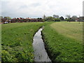
The Arrowe Brook
A feature of the linear park
Image: © Ian Greig
Taken: 16 Jun 2017
0.09 miles
2
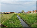
Arrowe Brook from Town Meadow Lane
Arrowe Brook, which begins near Thingwall, passes through Arrowe Country Park before its discharge into The Birket soon after Town Meadow Lane bridge from where this photo was taken.
Image: © Sue Adair
Taken: 19 Apr 2012
0.10 miles
4
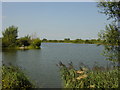
Lingham Mere
All that remains of this once large mere is a tiny corner, the rest has been used as a landfill site for the nearby brickworks. The river Birkett (from which Birkenhead gets its name, a corruption of Birkett head) flows nearby. It is now used for fishing.
Image: © Sue Adair
Taken: 17 Aug 2005
0.19 miles