IMAGES TAKEN NEAR TO
Coppice Grange, WIRRAL, CH46 6ED
Introduction
This page details the photographs taken nearby to Coppice Grange, CH46 6ED by members of the Geograph project.
The Geograph project started in 2005 with the aim of publishing, organising and preserving representative images for every square kilometre of Great Britain, Ireland and the Isle of Man.

There are currently over 7.5m images from over14,400 individuals and you can help contribute to the project by visiting https://www.geograph.org.uk
Image Map
Images are licensed for reuse under creativecommons.org/licenses/by-sa/2.0
Notes
- Clicking on the map will re-center to the selected point.
- The higher the marker number, the further away the image location is from the centre of the postcode.
Image Listing (13 Images Found)
Images are licensed for reuse under creativecommons.org/licenses/by-sa/2.0
Image
Details
Distance
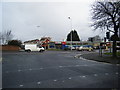
1
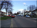
Hoylake Road (A553)
Heading east towards Birkenhead.
Image: © JThomas
Taken: 1 Mar 2014
0.08 miles
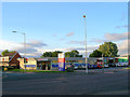
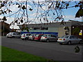
2
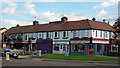
Urban Retail
Retail outlets at junction of Hoylake Road (A553) and Saughall Road, Moreton.
Image: © J Scott
Taken: 16 Oct 2010
0.08 miles
4
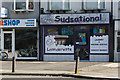
Sudsational
They have appeared to expand the basic launderette concept in all logical areas and survived where most have failed.
Image: © Ian Greig
Taken: 26 May 2017
0.09 miles
6
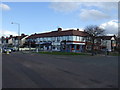
Tesco Express
The Tesco Express at the junction of Saughall Road / Millhouse Lane and the A553 Hoylake Road.
Image: © David P Howard
Taken: 23 Jul 2012
0.10 miles
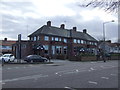
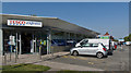
9
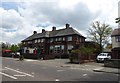
The Grange, Hoylake Road
Licensed bar and grill in Moreton
Image: © Eirian Evans
Taken: 17 May 2016
0.11 miles
10
Every Little Helps
Tesco mini supermarket, Hoylake Road, Moreton
Image: © J Scott
Taken: 16 Oct 2010
0.11 miles