IMAGES TAKEN NEAR TO
The Beeches, WIRRAL, CH46 3SN
Introduction
This page details the photographs taken nearby to The Beeches, CH46 3SN by members of the Geograph project.
The Geograph project started in 2005 with the aim of publishing, organising and preserving representative images for every square kilometre of Great Britain, Ireland and the Isle of Man.

There are currently over 7.5m images from over14,400 individuals and you can help contribute to the project by visiting https://www.geograph.org.uk
Image Map
Images are licensed for reuse under creativecommons.org/licenses/by-sa/2.0
Notes
- Clicking on the map will re-center to the selected point.
- The higher the marker number, the further away the image location is from the centre of the postcode.
Image Listing (4 Images Found)
Images are licensed for reuse under creativecommons.org/licenses/by-sa/2.0
Image
Details
Distance
1
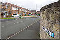
Oakmere Close, Leasowe
Cul-de-sac of modern houses leading off Leasowe Road.
Image: © Stephen McKay
Taken: 21 Nov 2019
0.11 miles
2
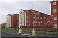
Leasowe Road
Modern blocks of flats overlook Leasowe Road between Moreton and Leasowe.
Image: © Stephen McKay
Taken: 21 Nov 2019
0.13 miles
3
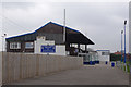
New Brighton Football Club
As the sign on the stand makes clear, this is a rugby union football club. It was formed in 1875 and its current home here at Hartsfield is in Leasowe, not New Brighton. The club runs three senior rugby teams and has squash courts and a junior section.
Image: © Stephen McKay
Taken: 21 Nov 2019
0.21 miles
4
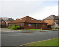
Blackheath Medical Centre.
A general practitioners surgery located off Reeds Lane.
Image: © David Quinn
Taken: 5 Jan 2008
0.22 miles