IMAGES TAKEN NEAR TO
Raleigh Road, WIRRAL, CH46 2RA
Introduction
This page details the photographs taken nearby to Raleigh Road, CH46 2RA by members of the Geograph project.
The Geograph project started in 2005 with the aim of publishing, organising and preserving representative images for every square kilometre of Great Britain, Ireland and the Isle of Man.

There are currently over 7.5m images from over14,400 individuals and you can help contribute to the project by visiting https://www.geograph.org.uk
Image Map (Loading...)


Getting Data...Please wait
Leaflet Map data © OpenStreetMap
Images are licensed for reuse under creativecommons.org/licenses/by-sa/2.0
Notes
- Clicking on the map will re-center to the selected point.
- The higher the marker number, the further away the image location is from the centre of the postcode.
Image Listing (5 Images Found)
Images are licensed for reuse under creativecommons.org/licenses/by-sa/2.0
Image
Details
Distance
3
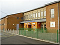
Leasowe Millennium Centre
A new community building with conference and wedding facilities, a cafe, a gym and community support services.
Image: © David Quinn
Taken: 5 Jan 2008
0.11 miles