IMAGES TAKEN NEAR TO
Cobham Road, WIRRAL, CH46 0QY
Introduction
This page details the photographs taken nearby to Cobham Road, CH46 0QY by members of the Geograph project.
The Geograph project started in 2005 with the aim of publishing, organising and preserving representative images for every square kilometre of Great Britain, Ireland and the Isle of Man.

There are currently over 7.5m images from over14,400 individuals and you can help contribute to the project by visiting https://www.geograph.org.uk
Image Map (Loading...)


Getting Data...Please wait
Leaflet Map data © OpenStreetMap
Images are licensed for reuse under creativecommons.org/licenses/by-sa/2.0
Notes
- Clicking on the map will re-center to the selected point.
- The higher the marker number, the further away the image location is from the centre of the postcode.
Image Listing (6 Images Found)
Images are licensed for reuse under creativecommons.org/licenses/by-sa/2.0
Image
Details
Distance
1
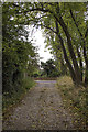
Altcar Drive
Altcar Drive, an unadopted road/footpath leading between two residential streets in Moreton.
Image: © William Starkey
Taken: 19 Oct 2013
0.08 miles
2
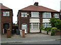
Where I Was Born
The house I was born in in 1961, we lived there till 1973. Taken on my birthday in 2008.
Image: © Dara Jasumani
Taken: 29 Aug 2008
0.19 miles
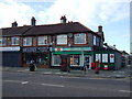
3

The Grange Public House, Moreton
Situated on Hoylake Road, at the junction with Acton Lane.
Image: © El Pollock
Taken: 23 Jul 2009
0.20 miles
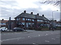
5
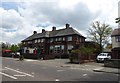
The Grange, Hoylake Road
Licensed bar and grill in Moreton
Image: © Eirian Evans
Taken: 17 May 2016
0.20 miles