IMAGES TAKEN NEAR TO
Rosclare Drive, WALLASEY, CH45 6UU
Introduction
This page details the photographs taken nearby to Rosclare Drive, CH45 6UU by members of the Geograph project.
The Geograph project started in 2005 with the aim of publishing, organising and preserving representative images for every square kilometre of Great Britain, Ireland and the Isle of Man.

There are currently over 7.5m images from over14,400 individuals and you can help contribute to the project by visiting https://www.geograph.org.uk
Image Map
Images are licensed for reuse under creativecommons.org/licenses/by-sa/2.0
Notes
- Clicking on the map will re-center to the selected point.
- The higher the marker number, the further away the image location is from the centre of the postcode.
Image Listing (4 Images Found)
Images are licensed for reuse under creativecommons.org/licenses/by-sa/2.0
Image
Details
Distance
1
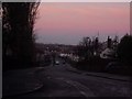
Taunton Road
Wallasey Sandhills are seen in the background. The skyscape is absolutely amazing here with the pinks, the reds and the blues all merging into one.
Image: © russ
Taken: Unknown
0.13 miles
2
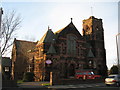
Claremount Road Methodist Church, Wallasey
Image: © Sue Adair
Taken: 9 Jan 2008
0.14 miles
4
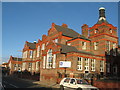
St George's Primary School, Wallasey
St George's Primary School was built in 1907.
Image: © Sue Adair
Taken: 9 Jan 2008
0.24 miles