IMAGES TAKEN NEAR TO
Ripon Road, WALLASEY, CH45 6TR
Introduction
This page details the photographs taken nearby to Ripon Road, CH45 6TR by members of the Geograph project.
The Geograph project started in 2005 with the aim of publishing, organising and preserving representative images for every square kilometre of Great Britain, Ireland and the Isle of Man.

There are currently over 7.5m images from over14,400 individuals and you can help contribute to the project by visiting https://www.geograph.org.uk
Image Map
Images are licensed for reuse under creativecommons.org/licenses/by-sa/2.0
Notes
- Clicking on the map will re-center to the selected point.
- The higher the marker number, the further away the image location is from the centre of the postcode.
Image Listing (13 Images Found)
Images are licensed for reuse under creativecommons.org/licenses/by-sa/2.0
Image
Details
Distance
1
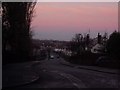
Taunton Road
Wallasey Sandhills are seen in the background. The skyscape is absolutely amazing here with the pinks, the reds and the blues all merging into one.
Image: © russ
Taken: Unknown
0.07 miles
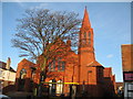
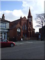
2
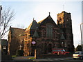
Claremount Road Methodist Church, Wallasey
Image: © Sue Adair
Taken: 9 Jan 2008
0.11 miles
3
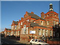
St George's Primary School, Wallasey
St George's Primary School was built in 1907.
Image: © Sue Adair
Taken: 9 Jan 2008
0.16 miles
4
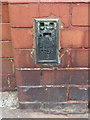
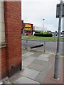
Ordnance Survey Flush Bracket 0258S
This Flush Bracket is on the St John's Road/Wallasey Road corner of David Trowler Associates Chartered Building Surveyors building. Although the flush bracket is in good condition, the hard Ruabon bricks show signs of damage from when the original hole was cut into them. See also: Image
Image: © John S Turner
Taken: 29 Jul 2014
0.20 miles
5
Wallasey, primary school
St. George's Primary School, on St. George's Road: http://www.stgeorges.wirral.sch.uk/
Image: © Mike Faherty
Taken: 4 Jul 2018
0.20 miles
6
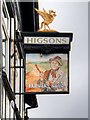
Farmers Arms Pub Sign, Wallasey Village
Sign outside Image
Image: © David Dixon
Taken: 6 Sep 2015
0.20 miles
7
Leasowe Road/Wallasey Road roundabout
Looking past the corner of the former bank, which is now the premises of David Trowler Associates, Chartered Building Surveyors. Ordnance Survey Flush Bracket 0258S can be seen on the left of the photo Image The photo was taken from St John's Road.
Image: © John S Turner
Taken: 29 Jul 2014
0.21 miles
8
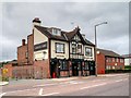
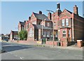
Farmers Arms, Wallasey Village
Wallasey Village is the most westerly township in Wallasey, being bordered by the suburbs of New Brighton to the north east, Liscard to the east and Poulton to the south east. Further west is Leasowe, and to the north, beyond Harrison Park, is the King's Parade fronting Liverpool Bay. Wallasey Village is a largely residential area with a mixture of mostly 20th century semi-detached and detached housing. There are various shops and pubs along the central road, Wallasey Village Road.
Image: © David Dixon
Taken: 6 Sep 2015
0.21 miles