IMAGES TAKEN NEAR TO
Thirlmere Drive, WALLASEY, CH45 4LN
Introduction
This page details the photographs taken nearby to Thirlmere Drive, CH45 4LN by members of the Geograph project.
The Geograph project started in 2005 with the aim of publishing, organising and preserving representative images for every square kilometre of Great Britain, Ireland and the Isle of Man.

There are currently over 7.5m images from over14,400 individuals and you can help contribute to the project by visiting https://www.geograph.org.uk
Image Map
Images are licensed for reuse under creativecommons.org/licenses/by-sa/2.0
Notes
- Clicking on the map will re-center to the selected point.
- The higher the marker number, the further away the image location is from the centre of the postcode.
Image Listing (19 Images Found)
Images are licensed for reuse under creativecommons.org/licenses/by-sa/2.0
Image
Details
Distance
1
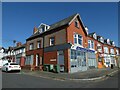
Corner shop, Thirlmere Drive, Wallasey
No longer used as a shop; providing a service for the community
Image: © David Smith
Taken: 28 Apr 2024
0.05 miles
2
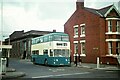
A historic occasion ? 28 June 1971 ? 1
Merseyside PTE bus 195 picks up passengers for the very first journey of the first regular daytime bus service through the Kingsway Tunnel between Wallasey and Liverpool, the day the tunnel opened to normal traffic.
The formation of the Passenger Transport Executive, which absorbed the bus and ferry operations of Wallasey and Birkenhead Corporations, allowed a more integrated public transport network. Previously, the only bus service through the (Queensway) tunnel had been the night service operated when no ferries ran.
Service 32 ran from the former Wallasey Corporation bus garage on Seaview Road through to Liverpool Exchange Station on Tithebarn Street https://www.geograph.org.uk/photo/7389262 .
This is one of a series of views featuring buses in the 60s, 70s, and 80s. http://www.geograph.org.uk/search.php?i=137652761
Bus 195 is a Leyland Atlantean with Northern Counties bodywork. It had been ordered by Birkenhead Corporation but was not delivered – in January 1971 – until after the formation of the PTE. It is in the PTE's Wirral division blue and cream livery, based on the colours used by the Birkenhead and Wallasey fleets. It also carries the route branding for the new cross-river services.
Image: © Alan Murray-Rust
Taken: 28 Jun 1971
0.08 miles
3
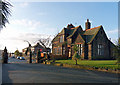
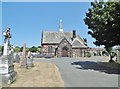
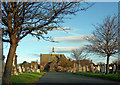
Eighteen Eighty Two
Cemetery Lodge at the entrance of Wallasey Cemetery, constructed in 1882.
Image: © J Scott
Taken: 21 Nov 2010
0.14 miles
4
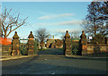
Gateway To The Past
Entrance to the grounds of Wallasey Cemetery.
Image: © J Scott
Taken: 21 Nov 2010
0.15 miles
5
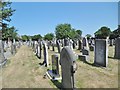
Wallasey Cemetery
Blue Flag-awarded cemetery on Rake Lane: http://www.wallaseycemetery.co.uk/history.html
Image: © Mike Faherty
Taken: 4 Jul 2018
0.16 miles
7
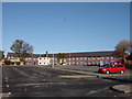
Wirral Local Government Offices, Liscard
Wirral Local Government Offices which are situated behind Seaview Road, Liscard. This is the rear of the building which was previously Egerton Grove Council School, erected in 1928.
Image: © Sue Adair
Taken: 13 Nov 2005
0.18 miles
8
Wallasey Cemetery, chapel
Off Rake Lane; also used for regular services by the Russian Orthodox Church, as the Church of St. Elizabeth the New Martyr. http://www.wallaseycemetery.co.uk/the-chapel.html#
Image: © Mike Faherty
Taken: 4 Jul 2018
0.18 miles
9
Liscard Chapel
Chapel in the grounds of Wallasey Cemetery.
Image: © J Scott
Taken: 21 Nov 2010
0.18 miles
10
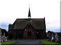
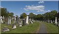
Rake Lane Chapel, Liscard
Situated in the grounds of Wallasey Cemetery.
Image: © El Pollock
Taken: 22 Jul 2009
0.20 miles