IMAGES TAKEN NEAR TO
Tide Way, WALLASEY, CH45 3NR
Introduction
This page details the photographs taken nearby to Tide Way, CH45 3NR by members of the Geograph project.
The Geograph project started in 2005 with the aim of publishing, organising and preserving representative images for every square kilometre of Great Britain, Ireland and the Isle of Man.

There are currently over 7.5m images from over14,400 individuals and you can help contribute to the project by visiting https://www.geograph.org.uk
Image Map
Images are licensed for reuse under creativecommons.org/licenses/by-sa/2.0
Notes
- Clicking on the map will re-center to the selected point.
- The higher the marker number, the further away the image location is from the centre of the postcode.
Image Listing (47 Images Found)
Images are licensed for reuse under creativecommons.org/licenses/by-sa/2.0
Image
Details
Distance
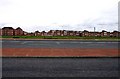
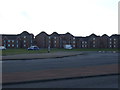
4
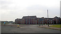
Sea front apartments
Complete with railway line behind them.
Image: © Steve Fareham
Taken: 7 Oct 2007
0.11 miles
5
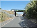
New Brighton, railway bridge
Carrying Wirral Lines over Sandcliffe Road.
Image: © Mike Faherty
Taken: 4 Jul 2018
0.12 miles
6
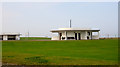
'Art Deco' toilets
At the west end of New Brighton sea front
Image: © Steve Fareham
Taken: 7 Oct 2007
0.13 miles
8

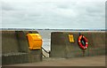
Promenade Stage Rally, New Brighton, The Wirral
Image: © Brian Deegan
Taken: 3 Sep 2016
0.13 miles
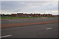
10
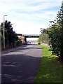
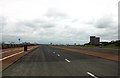
Railway Bridge, Sandcliffe Road, New Brighton
Looking towards New Brighton promenade.
Image: © El Pollock
Taken: 20 Jul 2009
0.14 miles