IMAGES TAKEN NEAR TO
Sunningdale Road, WALLASEY, CH45 0LU
Introduction
This page details the photographs taken nearby to Sunningdale Road, CH45 0LU by members of the Geograph project.
The Geograph project started in 2005 with the aim of publishing, organising and preserving representative images for every square kilometre of Great Britain, Ireland and the Isle of Man.

There are currently over 7.5m images from over14,400 individuals and you can help contribute to the project by visiting https://www.geograph.org.uk
Image Map
Images are licensed for reuse under creativecommons.org/licenses/by-sa/2.0
Notes
- Clicking on the map will re-center to the selected point.
- The higher the marker number, the further away the image location is from the centre of the postcode.
Image Listing (10 Images Found)
Images are licensed for reuse under creativecommons.org/licenses/by-sa/2.0
Image
Details
Distance
1
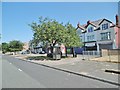
New Brighton, shopping parade
On Mount Road. Currently, convenience store, Chinese take-away, launderette, salon; other properties are residential or disused.
Image: © Mike Faherty
Taken: 4 Jul 2018
0.07 miles
2
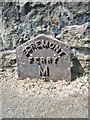
Old Milepost by Mount Road, New Brighton
Cast-iron post on the UC road, New Brighton, Merseyside; Mount Road, against side wall of No. 1 Ennerdale Road, West side of road. C19th, probably erected by the Wallasey Local Board in connection with goods or passenger transport.
Inscription reads:-
EGREMONT
FERRY
M
2
Milestone Society ID: CH_EGF02A.
Image: © Milestone Society
Taken: 4 Jul 2018
0.09 miles
3
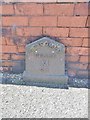
Old Milepost by Mount Road, New Brighton
Cast-iron post on the UC road, New Brighton, Merseyside; Mount Road, No. 54 against front wall, South-West side of road. C19, probably erected by the Wallasey Local Board in connection with goods or passenger transport.
Inscription reads:-
SEACOMBE
FERRY
M
2½
Milestone Society ID: CH_SCF02A.
Image: © Milestone Society
Taken: 4 Jul 2018
0.14 miles
4
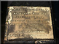
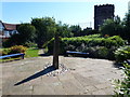
Dedication plaque for Mount Road Reservoir
Constructed in 1886 by the Wallasey Local Board.
Image: © Karl and Ali
Taken: 23 Feb 2018
0.18 miles
5
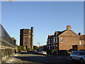
Wallasey Waterworks Tower, New Brighton
Now a century old, the tower of Wallasey Waterworks, like its neighbour the Church of SS Peter and Paul, is another landmark on the New Brighton skyline.
Image: © Sue Adair
Taken: 13 Nov 2005
0.20 miles
6
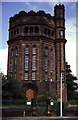
Water tower, Gorsehill Waterworks, Wallasey
Norman style water tower; part of Wallasey Waterworks that date back to 1905.
Image: © Chris Allen
Taken: 9 Aug 1987
0.21 miles
7
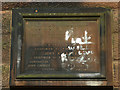
Dedication plaque on Wallasey Waterworks Tower
Set in the side of Image Sadly defaced by painted graffiti.
Image: © Karl and Ali
Taken: 23 Feb 2018
0.22 miles
8
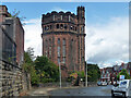
Water tower, Gorsehill Road, Wallasey
Built 1905 by J.H. Crowther. The younger and marginally daintier sister of Image Grade II listed.
Image: © Stephen Richards
Taken: 22 Aug 2014
0.22 miles
9
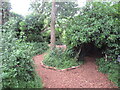
Gorse Millennium Green
Somewhere near the highest point in New Brighton. The area looks like it was once quarried.
Image: © Richard Webb
Taken: 26 May 2022
0.23 miles
10
Millennium Green, New Brighton
Millennium Green, New Brighton is accessed via a padlockable gate off Gorsehill Road. This is the view SW across the Millennium Green to the water tower. Gorse Hill, 57 metres, a P52 hill is in scrub land nearby.
Image: © Rude Health
Taken: 8 Aug 2012
0.24 miles