IMAGES TAKEN NEAR TO
Warren Drive, WALLASEY, CH45 0JT
Introduction
This page details the photographs taken nearby to Warren Drive, CH45 0JT by members of the Geograph project.
The Geograph project started in 2005 with the aim of publishing, organising and preserving representative images for every square kilometre of Great Britain, Ireland and the Isle of Man.

There are currently over 7.5m images from over14,400 individuals and you can help contribute to the project by visiting https://www.geograph.org.uk
Image Map
Images are licensed for reuse under creativecommons.org/licenses/by-sa/2.0
Notes
- Clicking on the map will re-center to the selected point.
- The higher the marker number, the further away the image location is from the centre of the postcode.
Image Listing (18 Images Found)
Images are licensed for reuse under creativecommons.org/licenses/by-sa/2.0
Image
Details
Distance
1
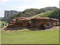
The Red Noses
An outcrop of red sandstone known locally as the Red Noses, there are also yellow noses nearby. Here there are wide grassy area for camping and playing games and nearby a miniature golf course and tennis courts and at the other side of the railway Warren Park Golf Course and Harrison Park.
Image: © Sue Adair
Taken: 17 Aug 2005
0.10 miles
2
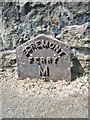
Old Milepost by Mount Road, New Brighton
Cast-iron post on the UC road, New Brighton, Merseyside; Mount Road, against side wall of No. 1 Ennerdale Road, West side of road. C19th, probably erected by the Wallasey Local Board in connection with goods or passenger transport.
Inscription reads:-
EGREMONT
FERRY
M
2
Milestone Society ID: CH_EGF02A.
Image: © Milestone Society
Taken: 4 Jul 2018
0.11 miles
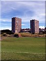
3
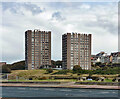
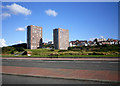
Cliff Estate, New Brighton
A pair of towers, their profiles appearing castellated, with what must be excellent views across Liverpool Bay. By Stephenson, Young & Partners, 1962.
Image: © Stephen Richards
Taken: 22 Aug 2014
0.15 miles
4
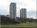
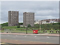
Tower blocks, Wellington Road, New Brighton
A pair of large tower blocks stand at the western end of Wellington Road and dominate the skyline on the New Brighton sea front.
Image: © Graham Robson
Taken: 26 Mar 2018
0.15 miles
5
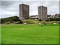
The Cliff, New Brighton
Flats with a view. Between the towers and sea there is a large area of undeveloped links.
Image: © Richard Webb
Taken: 26 May 2022
0.16 miles

7
Eyesore Seashore
Two random tower blocks dumped on the sea front, with trad buildings behind peering round them for a glimpse of the beach.
I guess the people in the blocks get a nice view.
Pity about everyone else.
Image: © Des Blenkinsopp
Taken: 21 Aug 2012
0.17 miles
8
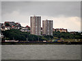
Tower Blocks at New Brighton (The Cliff)
A view from the entrance to the Mersey estuary looking towards the New Brighton seafront. Two, sixteen-storey concrete faced tower blocks dominate the surrounding area, even the higher level land to the south.
Image: © David Dixon
Taken: 13 Jul 2016
0.18 miles
9
Tower Blocks, "The Cliff", New Brighton
Two, sixteen-storey concrete faced tower blocks dominate the surrounding area, even the higher level land to the south.
Image: © David Dixon
Taken: 6 Sep 2015
0.18 miles
10
Tower Blocks, New Brighton
Situated at the end of Wellington Road, viewed from King's Parade.
Image: © El Pollock
Taken: 20 Jul 2009
0.18 miles