IMAGES TAKEN NEAR TO
Annesley Road, WALLASEY, CH44 9DA
Introduction
This page details the photographs taken nearby to Annesley Road, CH44 9DA by members of the Geograph project.
The Geograph project started in 2005 with the aim of publishing, organising and preserving representative images for every square kilometre of Great Britain, Ireland and the Isle of Man.

There are currently over 7.5m images from over14,400 individuals and you can help contribute to the project by visiting https://www.geograph.org.uk
Image Map
Images are licensed for reuse under creativecommons.org/licenses/by-sa/2.0
Notes
- Clicking on the map will re-center to the selected point.
- The higher the marker number, the further away the image location is from the centre of the postcode.
Image Listing (12 Images Found)
Images are licensed for reuse under creativecommons.org/licenses/by-sa/2.0
Image
Details
Distance
1
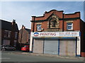
The Old Co-op Building Poulton Road
The Birkenhead and District Co-operative was established in 1891. This store was built around 1910 in Poulton Road, Somerville. Somerville gets its name from a house of that name built by James Fisher about 1850/60 and was where Hallville Road and Mollington Road are nowadays.
Image: © Sue Adair
Taken: 24 Aug 2019
0.09 miles
6
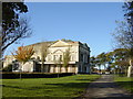
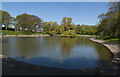
Liscard Hall, Central Park
In the early nineteenth century, Liscard Hall (then called Moor Heys House) and the surrounding parkland was home of Sir John Tobin, ship owner, merchant, African trader and one-time Mayor of Liverpool. On the death of his successor, son-in-law Harold Littledale in 1889, Wallasey Local Board bought the estate and opened it to the public on Whit Monday 1891. The building is disused and in disrepair having been used as a science and art college until 1982.
In the early hours of 7th of July 2008 this building was set ablaze, possibly by vandals, and has since been demolished. http://www.historyofwallasey.co.uk/wallasey/liscard_hall/index.html
Image: © Sue Adair
Taken: 13 Nov 2005
0.17 miles
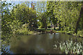
7
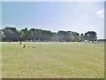
Wallasey Central Park
On Liscard Road, offering cricket, football, allotments, playground and grassland: http://www.centralpark.org.uk/
Image: © Mike Faherty
Taken: 4 Jul 2018
0.22 miles
8
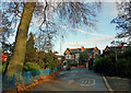
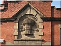
Faded Marks
Central Park exit to Liscard Road, Liscard.
Image: © J Scott
Taken: 21 Nov 2010
0.23 miles
9
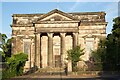
St John's Church, Egremont
St John's was built in 1832–33, and was designed by Henry Turberville Edwards; it is his only known work. The church was built on land owned by Sir John Tobin, whose son became the first vicar. The church was consecrated on 31 October 1831 by the Rt. Revd. John Bird Sumner, bishop of Chester, and it opened for worship on 19 May 1833. In 1881 it was restored by Cornelius Sherlock; this included removing the galleries, replacing box pews with benches, moving the organ, enclosing the chancel, and adding two new windows. In 1942 the church was damaged by a bomb blast, and was repaired in the 1950s with a new roof. It was declared redundant on 1 July 2004, and approval for conversion into residential use was agreed on 6 December 2006. As of August 2018 the church was put into private ownership with the intention of reopening it as Church again.
* Courtesy Wikipedia
Image: © Arthur C Harris
Taken: 21 Jun 2022
0.23 miles
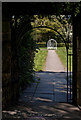
10
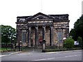
St. John's Church, Liscard Road, Egremont
Situated next to Central Park, opposite Church Street.
Image: © El Pollock
Taken: 22 Jul 2009
0.23 miles