IMAGES TAKEN NEAR TO
Geneva Road, WALLASEY, CH44 7EY

Introduction

This page details the photographs taken nearby to Geneva Road, CH44 7EY by members of the Geograph project.

The Geograph project started in 2005 with the aim of publishing, organising and preserving representative images for every square kilometre of Great Britain, Ireland and the Isle of Man.

There are currently over 7.5m images from over14,400 individuals and you can help contribute to the project by visiting https://www.geograph.org.uk

Image Map


Images are licensed for reuse under creativecommons.org/licenses/by-sa/2.0
Notes
  • Clicking on the map will re-center to the selected point.
  • The higher the marker number, the further away the image location is from the centre of the postcode.

Image Listing (11 Images Found)

Images are licensed for reuse under creativecommons.org/licenses/by-sa/2.0
Image
Details
Distance
1
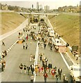
Kingsway Tunnel Public Walk
The Kingsway Tunnel linking Liverpool with Wallasey was officially opened by Queen Elizabeth II on 24th of June 1971. On the Sunday after the official opening (27th of June) the tunnel was made available to the public to walk through. Tickets cost 25p for an adult and 10p for a child which included a return trip on the Mersey ferry.
Image: © Sue Adair Taken: 27 Jun 1971
0.10 miles
2
Kingsway Tunnel Entrance, Wallasey
The road bridge in the foreground is Wheatland Lane.
Image: © El Pollock Taken: 1 Mar 2012
0.11 miles
3
Toll Plaza, Kingsway Tunnel, Birkenhead
Image: © Ian S Taken: 24 Jul 2019
0.19 miles
4
Kingsway Toll station
Opened in 1971 to relieve traffic going through the Queensway tunnel, the Kingsway tunnel carries the A59 from Wallasey to Liverpool.
Image: © Eirian Evans Taken: 14 May 2016
0.20 miles
5
Toll for Kingsway Tunnel
Image: © Alex McGregor Taken: 6 May 2014
0.21 miles
6
Seacombe - aerial view
An aerial image so the grid references are approximate.
Image: © Richard Hoare Taken: 5 May 2016
0.24 miles
7
Seacombe, Home Furnishing Centre
Former business on Borough Road, with signage from a bingo hall still on show.
Image: © Mike Faherty Taken: 4 Jul 2018
0.24 miles
8
Detail of former cinema, Borough Road, Wallasey
Surviving detail on this disused building Image
Image: © Stephen Richards Taken: 22 Aug 2014
0.24 miles
9
Demolition of Flour Mills, Wallasey Docks
Unusual method of demolition. Other flour-mills are now being converted to apartment flats.
Image: © Peter Craine Taken: Unknown
0.25 miles
10
East Float Dock, Wallasey
The tugboats coming to assist a ship in another dock are Thorngarth (right) and Svitzer Stanlow (left). The re-development of the old flour warehouses are underway. I'm pretty convinced that they were used in the film '51st State' (the exterior shot of the club scene).
Image: © Peter Craine Taken: 11 Feb 2007
0.25 miles