IMAGES TAKEN NEAR TO
Palatine Road, WALLASEY, CH44 7EN
Introduction
This page details the photographs taken nearby to Palatine Road, CH44 7EN by members of the Geograph project.
The Geograph project started in 2005 with the aim of publishing, organising and preserving representative images for every square kilometre of Great Britain, Ireland and the Isle of Man.

There are currently over 7.5m images from over14,400 individuals and you can help contribute to the project by visiting https://www.geograph.org.uk
Image Map
Images are licensed for reuse under creativecommons.org/licenses/by-sa/2.0
Notes
- Clicking on the map will re-center to the selected point.
- The higher the marker number, the further away the image location is from the centre of the postcode.
Image Listing (6 Images Found)
Images are licensed for reuse under creativecommons.org/licenses/by-sa/2.0
Image
Details
Distance
1
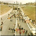
Kingsway Tunnel Public Walk
The Kingsway Tunnel linking Liverpool with Wallasey was officially opened by Queen Elizabeth II on 24th of June 1971. On the Sunday after the official opening (27th of June) the tunnel was made available to the public to walk through. Tickets cost 25p for an adult and 10p for a child which included a return trip on the Mersey ferry.
Image: © Sue Adair
Taken: 27 Jun 1971
0.10 miles
2
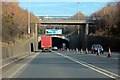
Kingsway Tunnel Entrance, Wallasey
The road bridge in the foreground is Wheatland Lane.
Image: © El Pollock
Taken: 1 Mar 2012
0.10 miles
4
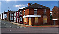
Dot's Diner
Dot's Diner on Birkenhead Road.
Image: © Peter McDermott
Taken: 25 May 2017
0.22 miles
5

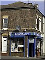
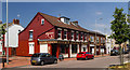
The Liver View, Church Road
Hotel in what was earlier named Russell Buildings, dated 1924.
Image: © Arthur C Harris
Taken: 25 Sep 2022
0.23 miles