IMAGES TAKEN NEAR TO
Stourton Street, WALLASEY, CH44 4BD
Introduction
This page details the photographs taken nearby to Stourton Street, CH44 4BD by members of the Geograph project.
The Geograph project started in 2005 with the aim of publishing, organising and preserving representative images for every square kilometre of Great Britain, Ireland and the Isle of Man.

There are currently over 7.5m images from over14,400 individuals and you can help contribute to the project by visiting https://www.geograph.org.uk
Image Map
Images are licensed for reuse under creativecommons.org/licenses/by-sa/2.0
Notes
- Clicking on the map will re-center to the selected point.
- The higher the marker number, the further away the image location is from the centre of the postcode.
Image Listing (5 Images Found)
Images are licensed for reuse under creativecommons.org/licenses/by-sa/2.0
Image
Details
Distance
1
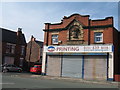
The Old Co-op Building Poulton Road
The Birkenhead and District Co-operative was established in 1891. This store was built around 1910 in Poulton Road, Somerville. Somerville gets its name from a house of that name built by James Fisher about 1850/60 and was where Hallville Road and Mollington Road are nowadays.
Image: © Sue Adair
Taken: 24 Aug 2019
0.17 miles

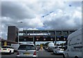
5
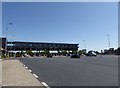
Kingsway Toll station
Opened in 1971 to relieve traffic going through the Queensway tunnel, the Kingsway tunnel carries the A59 from Wallasey to Liverpool.
Image: © Eirian Evans
Taken: 14 May 2016
0.19 miles