IMAGES TAKEN NEAR TO
Colville Road, WALLASEY, CH44 2AS
Introduction
This page details the photographs taken nearby to Colville Road, CH44 2AS by members of the Geograph project.
The Geograph project started in 2005 with the aim of publishing, organising and preserving representative images for every square kilometre of Great Britain, Ireland and the Isle of Man.

There are currently over 7.5m images from over14,400 individuals and you can help contribute to the project by visiting https://www.geograph.org.uk
Image Map
Images are licensed for reuse under creativecommons.org/licenses/by-sa/2.0
Notes
- Clicking on the map will re-center to the selected point.
- The higher the marker number, the further away the image location is from the centre of the postcode.
Image Listing (4 Images Found)
Images are licensed for reuse under creativecommons.org/licenses/by-sa/2.0
Image
Details
Distance
1

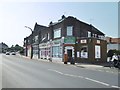
Shops along Wallasey Road, Liscard
Before WWII these shops, like others elsewhere in Wallasey, had glass-covered verandas. These were destroyed by the blast of a land mine which fell nearby.
The Wallasey History website has a good photograph from the pre-war period and details of the shops over the years: http://www.historyofwallasey.co.uk/wallasey/Shopping_In_Wallasey_Road/index.html
Image: © SK53
Taken: 18 Nov 2018
0.06 miles
2
Wallasey, shopping parade
On Wallasey Road; PO & store, sandwich bar, barbers, off-licence, accountants.
Image: © Mike Faherty
Taken: 4 Jul 2018
0.15 miles
3
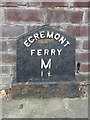
'Egremont Ferry M 1 ?' - Milepost in Wallasey Road, Wirral
This cast iron Egremont Ferry milepost stands in front of #213 Wallasey Road, near the junction with Claremount Road. Egremont Ferry dates back to the 18th century http://www.historyofwallasey.co.uk/wallasey/Wallasey_Ferries_Egremont_1761-1861/index.html but this milepost first appears on the 1935 O.S.map. See also Image
Inscription reads:-
EGREMONT
FERRY
M
1 ½
Milestone Society National ID: CH_EGF01B
Image: © John S Turner
Taken: 29 Jul 2014
0.24 miles
4
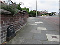
Wallasey Road and an Egremont Ferry milepost
Looking north west along Wallasey Road towards its junction with Claremount Road. There is a cast iron 'Egremont Ferry 1 1/2 M' milepost in front of #213 Wallasey Road - Image The history of Egremont Ferry dates back to the 18th century http://www.historyofwallasey.co.uk/wallasey/Wallasey_Ferries_Egremont_1761-1861/index.html , but this milepost first appears on the 1935 O.S. map.
Image: © John S Turner
Taken: 29 Jul 2014
0.24 miles