
IMAGES TAKEN NEAR TO
Rice Hey Road, WALLASEY, CH44 0DX
Introduction
This page details the photographs taken nearby to Rice Hey Road, CH44 0DX by members of the Geograph project.
The Geograph project started in 2005 with the aim of publishing, organising and preserving representative images for every square kilometre of Great Britain, Ireland and the Isle of Man.

There are currently over 7.5m images from over14,400 individuals and you can help contribute to the project by visiting https://www.geograph.org.uk
Image Map
Images are licensed for reuse under creativecommons.org/licenses/by-sa/2.0
Notes
- Clicking on the map will re-center to the selected point.
- The higher the marker number, the further away the image location is from the centre of the postcode.
Image Listing (5 Images Found)
Images are licensed for reuse under creativecommons.org/licenses/by-sa/2.0
Image
Details
Distance
1
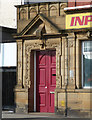
Detail of 48 King Street, Wallasey
Decorative entrance to a former bank.
Image: © Stephen Richards
Taken: 10 Jun 2013
0.23 miles
2
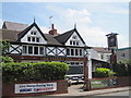
Saddle Inn Withins Lane
Originally named The Horse and Saddle Inn, it was once two separate cottages built about 1830. Yate's Brewery of Birkenhead purchased it for £750 in 1881 and most likely to have converted the cottages to a pub.
Image: © Sue Adair
Taken: 13 May 2019
0.24 miles
5
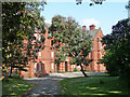
Gibson House, King Street, Wallasey
Built in 1906 for mariners' widows (complementing nearby Image]).
It has lain empty for more than a decade and its owner, Nautilus Welfare Fund, wants to demolish it, a plan that has been approved by Wirral Council. It may yet be saved by a last gasp rescue deal.
Image: © Stephen Richards
Taken: 10 Jun 2013
0.25 miles