IMAGES TAKEN NEAR TO
Hulleys Close, CHESTER, CH4 0YX
Introduction
This page details the photographs taken nearby to Hulleys Close, CH4 0YX by members of the Geograph project.
The Geograph project started in 2005 with the aim of publishing, organising and preserving representative images for every square kilometre of Great Britain, Ireland and the Isle of Man.

There are currently over 7.5m images from over14,400 individuals and you can help contribute to the project by visiting https://www.geograph.org.uk
Image Map
Images are licensed for reuse under creativecommons.org/licenses/by-sa/2.0
Notes
- Clicking on the map will re-center to the selected point.
- The higher the marker number, the further away the image location is from the centre of the postcode.
Image Listing (10 Images Found)
Images are licensed for reuse under creativecommons.org/licenses/by-sa/2.0
Image
Details
Distance
1

Stile for footpath from Daisy Bank Farm
Leading across grazing fields to Penymynydd
Image: © Maggie Cox
Taken: 25 Aug 2013
0.12 miles
2
Bridleway
Bridleway in Penyffordd going east towards Bank Farm.
Image: © Eirian Evans
Taken: 7 Dec 2007
0.17 miles
3
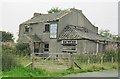
White Lion Inn
The White Lion Inn was located to the north of Penymynydd just along from St John's church on what was once a busy road between Chester and Mold. It was built in 1846 and provided accommodation for travellers and their horses. It was later a very popular pub but closed in 1992. This was all that was left in 2002.
Image: © Natalia A McKenzie
Taken: 17 Sep 2002
0.18 miles
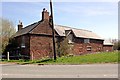
4
Derelict Building on Chester Road
An old building, possibly once a farm house on Chester Road at Penyffordd.
Image: © Jeff Buck
Taken: 2 May 2013
0.19 miles
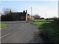
5

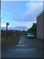
Old Hope Road, Penymynydd
Old Hope Road taken at the junction with Chester Road.
Image: © Jeff Buck
Taken: 2 May 2013
0.23 miles
6
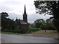
St John The Baptist at Penymynydd
Great Church building which is fully illuminated at night.
Image: © John Haynes
Taken: 26 Oct 2005
0.23 miles

8

Bench mark on Bank Farm, Penymynydd
This bench mark is on the north west corner, west face of Bank Farm, at the junction of Chester Road and Lower Mountain Road. See also Image
Image: © John S Turner
Taken: 15 Feb 2016
0.24 miles
9
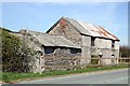
Bank Farm, Penymynydd
Disused buildings at Bank Farm on Chester Road at Penymynydd.
Image: © Jeff Buck
Taken: 2 May 2013
0.24 miles
10
Bank Farm, Penymynydd
Looking across Chester Road towards Bank Farm, Penymynydd. There's an Ordnance Survey bench mark on the nearest corner of the building - see Image
Image: © John S Turner
Taken: 15 Feb 2016
0.25 miles