IMAGES TAKEN NEAR TO
Messham Close, CHESTER, CH4 0TN
Introduction
This page details the photographs taken nearby to Messham Close, CH4 0TN by members of the Geograph project.
The Geograph project started in 2005 with the aim of publishing, organising and preserving representative images for every square kilometre of Great Britain, Ireland and the Isle of Man.

There are currently over 7.5m images from over14,400 individuals and you can help contribute to the project by visiting https://www.geograph.org.uk
Image Map
Images are licensed for reuse under creativecommons.org/licenses/by-sa/2.0
Notes
- Clicking on the map will re-center to the selected point.
- The higher the marker number, the further away the image location is from the centre of the postcode.
Image Listing (14 Images Found)
Images are licensed for reuse under creativecommons.org/licenses/by-sa/2.0
Image
Details
Distance
1
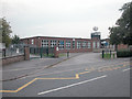
Broughton Infants School
Note the close proximity of what appear to be mobile phone aerials.
Image: © Dennis Turner
Taken: 31 Aug 2005
0.11 miles
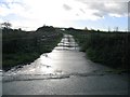
2
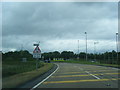
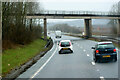
Bretton roundabout exit from North Wales Expressway
Image: © Colin Pyle
Taken: 16 Jun 2012
0.12 miles
3
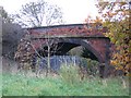
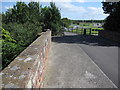
Broughton Railway Bridge
The bridge over the railway line, now disused, which went from Mold Junction at Saltney to Mold. The bridge used to carry the back lane from Broughton to Bretton, however, the developments of the Broughton retail park, and the A55 link from Broughton, have reduced it to a bridleway.
Image: © John S Turner
Taken: 15 Nov 2006
0.13 miles
4
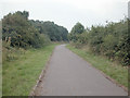
Broughton Bridleway
Bridleway close to Broughton retail park.
Image: © Dennis Turner
Taken: 31 Aug 2005
0.15 miles

6
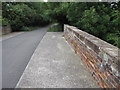
Broughton railway bridge and bridleway to the shopping park
The old railway bridge once carried the minor road between Broughton and Bretton over the Mold Junction line. The line was closed in the 1960s and the road has now been cut through by the A55 links. Nevertheless, the bridge still provides an important bridleway route to the shopping park behind the trees, and onwards to the old road to Bretton. The small dark mark on the parapet is the remains of a damaged rivet bench mark - see Image
Image: © John S Turner
Taken: 9 Sep 2009
0.16 miles
7
Bridge over the North Wales Expressway at Junction 36A (Broughton)
Image: © David Dixon
Taken: 14 Feb 2022
0.16 miles
8
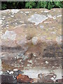
Damaged bench mark on Broughton railway bridge
This old rivet bench mark on the north side of the bridge has been almost completely destroyed. A bench mark was recorded at this location on the 1869 O.S. map.
Image: © John S Turner
Taken: 8 Sep 2009
0.17 miles
9
Broughton railway bridge and bridleway
The old road to Broughton from Bretton is now only a bridleway over the redundant railway bridge. On the far right of the photo the remains of a damaged bench mark can be seen - see Image
Image: © John S Turner
Taken: 8 Sep 2009
0.17 miles
10
Farm Road off Bretton Road
At this point the old Bretton Road, from Bretton to Broughton, becomes a Bridleway to Broughton and a footpath to the Broughton Retail Park. This farm road also leads off the truncated end of Bretton Road and provides the only means of getting to an island of land surrounded by the A55 and its spurs. Although most of this picture is in SJ3463, the SJ35 line goes diagonally from near left, across the farm lane where it turns left, and clips the right hand side of the road bridge in the distance.
Image: © John S Turner
Taken: 26 Nov 2006
0.18 miles