IMAGES TAKEN NEAR TO
Melwood Close, CHESTER, CH4 0NB
Introduction
This page details the photographs taken nearby to Melwood Close, CH4 0NB by members of the Geograph project.
The Geograph project started in 2005 with the aim of publishing, organising and preserving representative images for every square kilometre of Great Britain, Ireland and the Isle of Man.

There are currently over 7.5m images from over14,400 individuals and you can help contribute to the project by visiting https://www.geograph.org.uk
Image Map
Images are licensed for reuse under creativecommons.org/licenses/by-sa/2.0
Notes
- Clicking on the map will re-center to the selected point.
- The higher the marker number, the further away the image location is from the centre of the postcode.
Image Listing (27 Images Found)
Images are licensed for reuse under creativecommons.org/licenses/by-sa/2.0
Image
Details
Distance
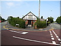
2
Junction of Hawarden Road and Famau View Drive
Image: © Eirian Evans
Taken: 12 Jul 2017
0.14 miles
3

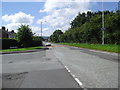
East along Chester Road, Penyffordd, Flintshire
Towards Penymynydd and the A5104. Penyffordd & Penymynydd War Memorial Institute https://www.geograph.org.uk/photo/5678048 is on the left.
Image: © Jaggery
Taken: 12 Feb 2018
0.15 miles
4
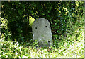
Old Milestone by Hawarden Road, Penyffordd
Milestone (plate lost) by the UC road (was A550), in parish of Penyffordd (Flintshire District), North of Hawarden Road junction with Crossways opposite.
Inscription once read:-
(Hawarden 2¾)
(Wrexham 8)
Surveyed
Milestone Society National ID: FLT_WRHW08
Image: © Christopher Leather
Taken: 18 May 2024
0.15 miles
5
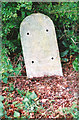
Old Milestone by Hawarden Road, Penyffordd
Milestone (plate lost) by the UC road (was A550), in parish of Penyffordd (Flintshire District), North of Hawarden Road junction with Crossways opposite.
Inscription once read:-
(Hawarden 2¾)
(Wrexham 8)
Surveyed
Milestone Society National ID: FLT_WRHW08
Image: © Milestone Society
Taken: Unknown
0.15 miles
6
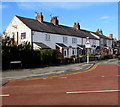
Belle Vue Terrace, Penymynydd Road, Penyffordd, Flintshire
Row of houses on the west side of Penymynydd Road, viewed across Chester Road.
Image: © Jaggery
Taken: 12 Feb 2018
0.18 miles
7
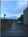
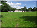
Bridleway
Bridleway in Penyffordd going east towards Bank Farm.
Image: © Eirian Evans
Taken: 7 Dec 2007
0.18 miles
8
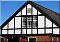
Year plaque on the wall of the War Memorial Institute, Penyffordd, Flintshire
The plaque on the wall here https://www.geograph.org.uk/photo/5678048 shows the year 1922.
Image: © Jaggery
Taken: 12 Feb 2018
0.18 miles
9
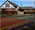
War Memorial Institute, Penyffordd, Flintshire
Penyffordd & Penymynydd War Memorial Institute dated 1922 https://www.geograph.org.uk/photo/5678059 is on the corner of Chester Road and Penymynydd Road in Penyffordd. The War Memorial Institute website states "Our mission is to keep the community of Penyffordd & Penymynydd connected by providing a central hub for community and charitable events".
Image: © Jaggery
Taken: 12 Feb 2018
0.18 miles
10
Penyffordd & Penymynydd War Memorial Institute
At the junction of Penymynydd Road and Chester Road
Image: © Maggie Cox
Taken: 25 Aug 2013
0.18 miles