IMAGES TAKEN NEAR TO
Watts Road, CHESTER, CH4 0HD
Introduction
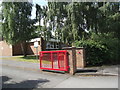
This page details the photographs taken nearby to Watts Road, CH4 0HD by members of the Geograph project.
The Geograph project started in 2005 with the aim of publishing, organising and preserving representative images for every square kilometre of Great Britain, Ireland and the Isle of Man.

There are currently over 7.5m images from over14,400 individuals and you can help contribute to the project by visiting https://www.geograph.org.uk
Image Map
Images are licensed for reuse under creativecommons.org/licenses/by-sa/2.0
Notes
- Clicking on the map will re-center to the selected point.
- The higher the marker number, the further away the image location is from the centre of the postcode.
Image Listing (74 Images Found)
Images are licensed for reuse under creativecommons.org/licenses/by-sa/2.0
Image
Details
Distance
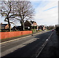
1
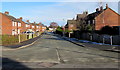
Wat's Road, Penyffordd, Flintshire
From Abbotts Lane along Wat's Road towards Vounog Hill.
Image: © Jaggery
Taken: 12 Feb 2018
0.01 miles
2
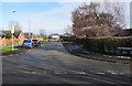
Park Crescent, Penyffordd, Flintshire
Cul-de-sac viewed across Abbotts Lane.
Image: © Jaggery
Taken: 12 Feb 2018
0.04 miles
3
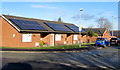
Rooftop solar panels, Park Crescent, Penyffordd, Flintshire
On the left here. https://www.geograph.org.uk/photo/5678670
Image: © Jaggery
Taken: 12 Feb 2018
0.05 miles
4
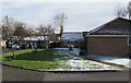
Snow remnants, Corwen Way, Penyffordd, Flintshire
Viewed on February 12th 2018.
Image: © Jaggery
Taken: 12 Feb 2018
0.05 miles
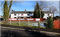
6
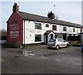
Red Lion, Penyffordd, Flintshire
Village pub on the corner of Rhos Road and Abbotts Lane.
Image: © Jaggery
Taken: 12 Feb 2018
0.06 miles
7
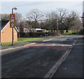
Warning sign - School/Ysgol, Abbotts Lane, Penyffordd, Flintshire
The English/Welsh sign incorporating a 20mph speed limit sign is alongside
a speed bump on the approach to Park Crescent and a primary school.
Image: © Jaggery
Taken: 12 Feb 2018
0.07 miles
8
Red Lion in Penyffordd, Flintshire
Abbotts Lane side of the village pub on the corner of Rhos Road. https://www.geograph.org.uk/photo/5691960 to the name sign on the left.
Image: © Jaggery
Taken: 12 Feb 2018
0.07 miles
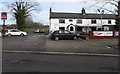
9
Abbotts Lane, Penyffordd, Flintshire
From the corner of Rhos Road along Abbotts Lane towards the Wat's Road junction. https://www.geograph.org.uk/photo/5678620
Image: © Jaggery
Taken: 12 Feb 2018
0.07 miles
10
Banners on a Red Lion fence, Penyffordd, Flintshire
Viewed on February 12th 2018. The banner on the left shows BOOK NOW for the Valentine's Day special at the Red Lion on February 14th. Other banners advertise the weekly Fish Friday and Steak Night every Wednesday.
Image: © Jaggery
Taken: 12 Feb 2018
0.08 miles