IMAGES TAKEN NEAR TO
Poplar Court, CHESTER, CH4 0FP
Introduction
This page details the photographs taken nearby to Poplar Court, CH4 0FP by members of the Geograph project.
The Geograph project started in 2005 with the aim of publishing, organising and preserving representative images for every square kilometre of Great Britain, Ireland and the Isle of Man.

There are currently over 7.5m images from over14,400 individuals and you can help contribute to the project by visiting https://www.geograph.org.uk
Image Map
Images are licensed for reuse under creativecommons.org/licenses/by-sa/2.0
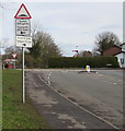
Notes
- Clicking on the map will re-center to the selected point.
- The higher the marker number, the further away the image location is from the centre of the postcode.
Image Listing (97 Images Found)
Images are licensed for reuse under creativecommons.org/licenses/by-sa/2.0
Image
Details
Distance
1
Ffordd Haearn, Penyffordd, Flintshire
Cul-de-sac on the north side of Towers Way.
Ffordd Haearn is Welsh for Iron Road.
The nearby name sign https://www.geograph.org.uk/photo/5678166 is in Welsh only.
Image: © Jaggery
Taken: 12 Feb 2018
0.06 miles
2
Welsh-only name sign, Ffordd Haearn, Penyffordd, Flintshire
Facing Towers Way. Ffordd Haearn is Welsh for Iron Road.
Image: © Jaggery
Taken: 12 Feb 2018
0.08 miles
3
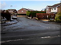
Snow remnants, Towers Way, Penyffordd, Flintshire
Near the corner of Priory Close on February 12th 2018.
Image: © Jaggery
Taken: 12 Feb 2018
0.09 miles
4
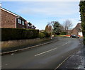
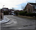
Towers Way junction, Penyffordd, Flintshire
Rhos Road is on the left, Corwen Road on the right.
Image: © Jaggery
Taken: 12 Feb 2018
0.09 miles
5
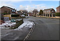
Priory Close, Penyffordd, Flintshire
Cul-de-sac on the southwest side of Towers Way. Remnants of recent snow are on the pavement on the left and roofs in the background on February 12th 2018.
Image: © Jaggery
Taken: 12 Feb 2018
0.10 miles
6
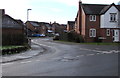
Poppy Field Drive, Penyffordd, Flintshire
Viewed across Silver Birch Way.
Image: © Jaggery
Taken: 12 Feb 2018
0.11 miles
7
Patchy snow in Penyffordd, Flintshire
On a grass strip between Corwen Road and Corwen Way on February 12th 2018.
Image: © Jaggery
Taken: 12 Feb 2018
0.12 miles
8
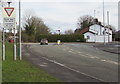
GIVE WAY 50 yards/ILDIWCH 50 llath, Corwen Road, Penyffordd, Flintshire
The English/Welsh sign is on the approach to the Hawarden Road/Vounog Hill T-junction.
Image: © Jaggery
Taken: 12 Feb 2018
0.12 miles
9
Warning sign - humps to the left and right ahead, Corwen Road, Penyffordd, Flintshire
On the approach to the Hawarden Road/Vounog Hill T-junction. The text is also in Welsh.
Image: © Jaggery
Taken: 12 Feb 2018
0.13 miles
10
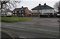
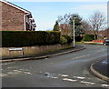
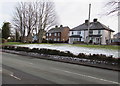
Corwen Way houses, Penyffordd, Flintshire
Viewed across Corwen Road from the corner of Towers Way.
Image: © Jaggery
Taken: 12 Feb 2018
0.13 miles