IMAGES TAKEN NEAR TO
Vounog Hill, CHESTER, CH4 0EY
Introduction
This page details the photographs taken nearby to Vounog Hill, CH4 0EY by members of the Geograph project.
The Geograph project started in 2005 with the aim of publishing, organising and preserving representative images for every square kilometre of Great Britain, Ireland and the Isle of Man.

There are currently over 7.5m images from over14,400 individuals and you can help contribute to the project by visiting https://www.geograph.org.uk
Image Map
Images are licensed for reuse under creativecommons.org/licenses/by-sa/2.0
Notes
- Clicking on the map will re-center to the selected point.
- The higher the marker number, the further away the image location is from the centre of the postcode.
Image Listing (91 Images Found)
Images are licensed for reuse under creativecommons.org/licenses/by-sa/2.0
Image
Details
Distance
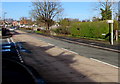
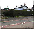
1
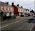
Vounog Hill houses and speed bump, Penyffordd, Flintshire
Looking south away from the centre of the village.
Image: © Jaggery
Taken: 12 Feb 2018
0.02 miles
2
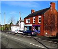
Penyffordd Pharmacy, Penyffordd, Flintshire
The pharmacy is at 1 Vounog Hill on the corner of Station Way.
Carolann Hair salon on the right is at 3 Vounog Hill.
Image: © Jaggery
Taken: 12 Feb 2018
0.04 miles
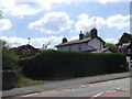
3
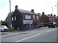
Penyffordd Pharmacy
One of a handful of shops in Penyffordd
Image: © Eirian Evans
Taken: 12 Jul 2017
0.04 miles
4
Station House, Station Way, Penyffordd, Flintshire
On the corner of Vounog Hill, this location was the site of Hope & Penyffordd railway station on the line from Mold to Saltney Junction near Chester. Passenger services on this route ended in 1962. In 2018, the nearest railway station is about a kilometre to the west - Penyffordd station on the Borderlands Line from Wrexham to Bidston.
Image: © Jaggery
Taken: 12 Feb 2018
0.06 miles
5
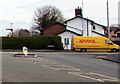
Yellow DHL van, Vounog Hill, Penyffordd, Flintshire
DHL provides courier services for parcel delivery in the UK and internationally.
Image: © Jaggery
Taken: 12 Feb 2018
0.06 miles
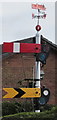
6
Corwen direction sign, Vounog Hill, Penyffordd, Flintshire
The sign on the lamppost points towards Corwen Road. The Vounog Hill name sign https://www.geograph.org.uk/photo/5678884 is in the hedge nearby.
Image: © Jaggery
Taken: 12 Feb 2018
0.06 miles
7
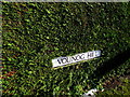
Vounog Hill name sign in a hedge, Penyffordd, Flintshire
Opposite the Corwen Road junction, the sign is in the hedge on the right here. https://www.geograph.org.uk/photo/5679002 According to one online source, this is the only Vounog (Hill or Street or Road or Crescent or Avenue etc) in the UK. Vounog looks like an anglicised version of a Welsh word.
Image: © Jaggery
Taken: 12 Feb 2018
0.06 miles
8
Steam locomotive weather vane, Penyffordd, Flintshire
Located here. https://www.geograph.org.uk/photo/5699541
Image: © Jaggery
Taken: 12 Feb 2018
0.06 miles
9
Semaphore signal behind a hedge, Penyffordd, Flintshire
The signal is a reminder that this was the site of Hope & Penyffordd railway station on the line from Mold to Saltney Junction near Chester. Passenger services on this route ended in 1962. https://www.geograph.org.uk/photo/5699544 to a closer view of the signal and the weather vane on top of it. See http://www.geograph.org.uk/photo/5678972 for the adjacent Station House.
Image: © Jaggery
Taken: 12 Feb 2018
0.06 miles
10
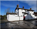
Former station, Penyffordd
Was on the Chester-Mold-Denbigh Line, but it was closed in 1962. Still retains the signals in the rear garden.
Image: © Eirian Evans
Taken: 12 Jul 2017
0.06 miles