IMAGES TAKEN NEAR TO
Min Y Ddol, Vounog Hill, CHESTER, CH4 0EB
Introduction
This page details the photographs taken nearby to Min Y Ddol, Vounog Hill, CH4 0EB by members of the Geograph project.
The Geograph project started in 2005 with the aim of publishing, organising and preserving representative images for every square kilometre of Great Britain, Ireland and the Isle of Man.

There are currently over 7.5m images from over14,400 individuals and you can help contribute to the project by visiting https://www.geograph.org.uk
Image Map
Images are licensed for reuse under creativecommons.org/licenses/by-sa/2.0
Notes
- Clicking on the map will re-center to the selected point.
- The higher the marker number, the further away the image location is from the centre of the postcode.
Image Listing (6 Images Found)
Images are licensed for reuse under creativecommons.org/licenses/by-sa/2.0
Image
Details
Distance
1
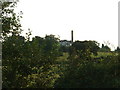
Hospital
I don't know what sort of hospital. The mock-tudor walls seem somewhat incongruous next to the typical hospital chimney.
Image: © David Medcalf
Taken: 25 Jul 2006
0.04 miles
2
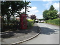
Old Telephone Kiosk, Pen-y-Ffordd
At the junction of Vounog Road and Alyn Drive, just an empty kiosk
Image: © Eirian Evans
Taken: 12 Jul 2017
0.12 miles
4
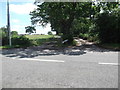
Two driveways
One to a farm, on the left, and the other to a converted barn.
Image: © Eirian Evans
Taken: 12 Jul 2017
0.19 miles
5
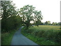
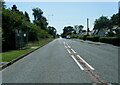
Lane at Blackbrook
The '40s map shows a railway to the left of the road - only a bramble thicket exists there now.
Image: © David Medcalf
Taken: 25 Jul 2006
0.24 miles
6
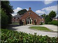
Emmanuel Church
Emmanuel Church on Vounog Hill, in Pen-y-ffordd, was built in 1959. The church was extended and refurbished in October 2011.
Image: © Eirian Evans
Taken: 12 Jul 2017
0.25 miles