
IMAGES TAKEN NEAR TO
Chester Road, CHESTER, CH4 0DF
Introduction
This page details the photographs taken nearby to Chester Road, CH4 0DF by members of the Geograph project.
The Geograph project started in 2005 with the aim of publishing, organising and preserving representative images for every square kilometre of Great Britain, Ireland and the Isle of Man.

There are currently over 7.5m images from over14,400 individuals and you can help contribute to the project by visiting https://www.geograph.org.uk
Image Map
Images are licensed for reuse under creativecommons.org/licenses/by-sa/2.0
Notes
- Clicking on the map will re-center to the selected point.
- The higher the marker number, the further away the image location is from the centre of the postcode.
Image Listing (4 Images Found)
Images are licensed for reuse under creativecommons.org/licenses/by-sa/2.0
Image
Details
Distance
1

Sunset and a silhouetted tree near Hope's Place
This tree, alongside the lane to Hope's Place, is silhouetted by the winter sun, whilst a layer of mist rises from the surrounding fields. A spontaneous photograph taken from the top deck of a moving bus.
Image: © John S Turner
Taken: 9 Jan 2013
0.16 miles
2
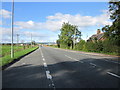
The A5104 (Chester Road), Saltney
The A5104 (Chester Road) heading west out of Saltney at the junctions of Hope's Palace and Well House Farm.
Wikipedia http://en.wikipedia.org/wiki/Saltney
Image: © Jeff Buck
Taken: 10 Oct 2013
0.18 miles
3
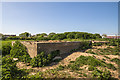
North Wales WWII defences: Hawarden Airfield Defence - Pillbox with attached HAA pit (1)
-
Pillbox (variant): DoB ID: S0011359
Described as a type 26 or type 23 pillbox with a concrete hexagonal HAA pit attached to one side, the latter being heavily overgrown.
Image
Image: © Mike Searle
Taken: 10 May 2017
0.24 miles
4
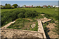
North Wales WWII defences: Hawarden Airfield Defence - Pillbox with attached HAA pit (2)
-
Pillbox (variant): DoB ID: S0011359
Image: © Mike Searle
Taken: 10 May 2017
0.24 miles