IMAGES TAKEN NEAR TO
Chester Road, CHESTER, CH4 0DB
Introduction
This page details the photographs taken nearby to Chester Road, CH4 0DB by members of the Geograph project.
The Geograph project started in 2005 with the aim of publishing, organising and preserving representative images for every square kilometre of Great Britain, Ireland and the Isle of Man.

There are currently over 7.5m images from over14,400 individuals and you can help contribute to the project by visiting https://www.geograph.org.uk
Image Map
Images are licensed for reuse under creativecommons.org/licenses/by-sa/2.0
Notes
- Clicking on the map will re-center to the selected point.
- The higher the marker number, the further away the image location is from the centre of the postcode.
Image Listing (5 Images Found)
Images are licensed for reuse under creativecommons.org/licenses/by-sa/2.0
Image
Details
Distance
1
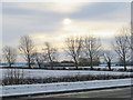
A wintry scene in Saltney Ferry
Looking across the A5104 towards the golf driving range on a cold and wintry afternoon.
Image: © John S Turner
Taken: 12 Dec 2017
0.13 miles
2
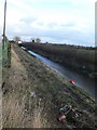
Drainage Ditch alongside the Chester Road, Saltney Ferry
Saltney is a very low-lying area of Flintshire and drainage ditches run along field boundaries.
Image: © Eirian Evans
Taken: 7 Dec 2007
0.23 miles
3
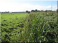
Bulrushes by the A5104
Viewed from the lane to Bretton Hall, bulrushes fill the drainage ditch on the south of the A5104 old turnpike road between Chester and Broughton. The ditch is an important part of the drainage system for the former marshland, and it is regularly cleaned out.
Image: © John S Turner
Taken: 9 Sep 2009
0.24 miles
4
Private road to Bretton Hall
This private lane off the A5104 leads to Bretton Hall and Bretton Hall Farm. There is also access to the golf driving range, on the left, immediately after crossing the drainage ditch. The old narrow bridge over the deep roadside ditch once had an Ordnance Survey First Geodetic Levelling bench mark on the west side, but the narrow bridge has been widened in modern times to allow for larger vehicles, and the bridge is now brick and concrete - see Image The current O.S. database suggests that there is a new rivet and cut mark there on the east side, but if so it will be hidden by the thick summer plant growth.
Image: © John S Turner
Taken: 9 Sep 2009
0.24 miles
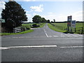
5
Bridge and lane to Bretton Hall
Here the lane to Bretton Hall crosses the drainage ditch, which is alongside the A5104. The bridge and ditch are well hidden by the summer's growth of bulrushes. The old narrow bridge once had a First Geodetic Levelling bench mark, but the current bridge seems to be more modern, is built of bricks and concrete, and is the width of the lane. The entrance to the golf driving range can be seen across the lane.
Image: © John S Turner
Taken: 9 Sep 2009
0.25 miles