
IMAGES TAKEN NEAR TO
Lester Lane, CHESTER, CH4 0DA
Introduction
This page details the photographs taken nearby to Lester Lane, CH4 0DA by members of the Geograph project.
The Geograph project started in 2005 with the aim of publishing, organising and preserving representative images for every square kilometre of Great Britain, Ireland and the Isle of Man.

There are currently over 7.5m images from over14,400 individuals and you can help contribute to the project by visiting https://www.geograph.org.uk
Image Map
Images are licensed for reuse under creativecommons.org/licenses/by-sa/2.0
Notes
- Clicking on the map will re-center to the selected point.
- The higher the marker number, the further away the image location is from the centre of the postcode.
Image Listing (11 Images Found)
Images are licensed for reuse under creativecommons.org/licenses/by-sa/2.0
Image
Details
Distance
1
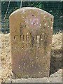
Modern Boundary Marker by Lesters Lane, Bretton
Parish Boundary Marker by the UC road, in parish of Chester (Chester District), Lesters Lane, Bretton, at entrance to waterworks.
Inscription reads:- : CHESTER / 2002 :
To be surveyed
Milestone Society National ID: CH_CHES04pb.
Image: © John S Turner
Taken: 8 Aug 2016
0.03 miles
2
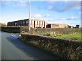
Bretton Waterworks
Bretton Waterworks on Lesters Lane taken from Brick Road.
Image: © John S Turner
Taken: 26 Nov 2006
0.12 miles
3
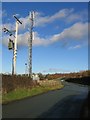
Mobile Phone Mast
A mobile phone mast on Brick Road, near Bretton, at its junction with Lesters Lane. Ahead, the road goes over the A55 and on into Bretton Village.
Image: © John S Turner
Taken: 26 Nov 2006
0.12 miles
4
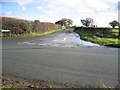
Lesters Lane near Bretton
The Lesters Lane Junction with Brick Road near Bretton. In the distance are the gates to Bretton Waterworks. Many years ago there used to be a stone 'mounting block' on the right hand corner, near the gap in the hedge, which assisted horse riders to remount their horses. Possibly this was primarily for the hunt, which used to meet at the end of the 'Duke's Drive' a short distance away, just about where the A55 is now.
Image: © John S Turner
Taken: 26 Nov 2006
0.12 miles
5
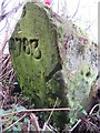
Old Boundary Marker in Dodleston parish
Parish Boundary Marker in parish of Dodleston (Chester District), at edge of field South of the A55. A post marks the stone to avoid further damage.
Inscription reads:-
(D) P
1783
Surveyed
Milestone Society National ID: CH_DODHAW03pb
Image: © John S Turner
Taken: 3 Feb 2017
0.15 miles
6
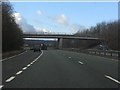
A55 - Brick Road overbridge
The minor road is carried over the A55 and (out of sight) the eastbound access from Broughton by two substantial structures. This one is made wider by accommodating the westbound exit slip road toward Broughton.
Image: © Peter Whatley
Taken: 18 Jan 2011
0.17 miles
7
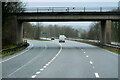
North Wales Expressway at Junction 36A (Broughton)
Image: © David Dixon
Taken: 14 Feb 2022
0.17 miles
8
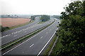
A 55 Trunk route at Broughton
Looking west. The slip road leads to Broughton Retail Park
Image: © Dennis Turner
Taken: 31 Aug 2005
0.19 miles
9

Airbus Beluga #3 from the footbridge over the A55
Viewed from the footbridge over the A55 it almost seems as though I am on the same level as the Beluga as it approaches Hawarden Airport.
Image: © John S Turner
Taken: 3 Feb 2017
0.22 miles
10
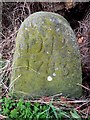
Old Boundary Marker near the A55, Dodleston Parish
Parish Boundary Marker in parish of Dodleston (Chester District), by ditch in field south of the A55, at the foot of a tree in a hedge. Marker post set up by the farmer to protect the stone from ploughing.
Inscription reads:- : DP / 1783 : : HP :
(DP = Dodleston Parish; HP = Hawarden Parish)
Surveyed
Milestone Society National ID: CH_DODHAW02pb
Image: © Milestone Society
Taken: 3 Feb 2017
0.23 miles