IMAGES TAKEN NEAR TO
Flint Road, CHESTER, CH4 0BW
Introduction
This page details the photographs taken nearby to Flint Road, CH4 0BW by members of the Geograph project.
The Geograph project started in 2005 with the aim of publishing, organising and preserving representative images for every square kilometre of Great Britain, Ireland and the Isle of Man.

There are currently over 7.5m images from over14,400 individuals and you can help contribute to the project by visiting https://www.geograph.org.uk
Image Map
Images are licensed for reuse under creativecommons.org/licenses/by-sa/2.0
Notes
- Clicking on the map will re-center to the selected point.
- The higher the marker number, the further away the image location is from the centre of the postcode.
Image Listing (39 Images Found)
Images are licensed for reuse under creativecommons.org/licenses/by-sa/2.0
Image
Details
Distance
1
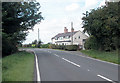
Riverside Cottages
Cottages on the banks of the River Dee near Saltney Ferry.
Image: © Dennis Turner
Taken: 30 Aug 2005
0.03 miles
2
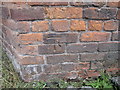
Bench mark on old barn at Cop House Farm
This bench mark is on the corner of the barn west of the entrance to Cop House Farm.
Image: © John S Turner
Taken: 5 Sep 2009
0.03 miles
4
Cop House Farm
Snuggled in under the south embankment of Afon Dyfrdwy.
Image: © John Haynes
Taken: 2 May 2012
0.05 miles
5
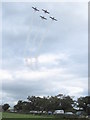
The Yakovlevs display team over Cop House Farm
The internationally famous Yakovlevs display team, who are based in Somerset, display at the Broughton Airbus Family Fun Day. Here they are banking over Cop House Farm to line up with the main runway at Hawarden Airport. For their displays the Yakovlevs use Russian built Yak 50s, and a specially built Super Yak 52 two seater. http://www.yakovlevs.com/
Image: © John S Turner
Taken: 5 Sep 2009
0.07 miles
6
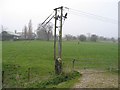
Stone Gatepost at Cop House Farm
This single stone gatepost can probably be dated to shortly after 1737 when the River Dee was canalised. The farmland only came into existence after the land was drained at that time. The Cop, or river bank, is still sometimes used for grazing cattle. The buildings in the distance are part of Cop House Farm, and much of the land beyond the gateway is in the next square.
Image: © John S Turner
Taken: 27 Mar 2007
0.07 miles
7
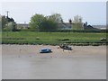
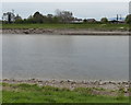
Boats on the bank of the River Dee
Viewed across the River Dee, at low tide, from the cycleway that runs from Chester to Queensferry and beyond. Cop House cottages can be seen behind the hedge and trees, and the building to the left is part of Cop House Farm on the other side of the B5129, Flint Road.
Image: © John S Turner
Taken: 20 Apr 2007
0.08 miles
8
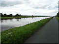
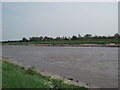
The River Dee
View from the Wales Coast Path.
Image: © JThomas
Taken: 15 Jun 2019
0.10 miles
9
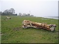
Tree Trunk by the River Dee
These tree trunks show how far the high tides can spread up onto the river bank taking these large trees with them. The tide is very low in this photo. Cop House cottages can be seen in the distance.
Image: © John S Turner
Taken: 27 Mar 2007
0.10 miles
10
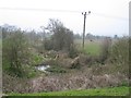
Pond at Cop House Farm
This rough wet area is immediately behind the river bank but doesn't appear to have any means of draining into the river. It must be a wildlife haven in the middle of the farmland.
Image: © John S Turner
Taken: 27 Mar 2007
0.11 miles