IMAGES TAKEN NEAR TO
Aviation Park, Flint Road, CHESTER, CH4 0BB
Introduction
This page details the photographs taken nearby to Aviation Park, Flint Road, CH4 0BB by members of the Geograph project.
The Geograph project started in 2005 with the aim of publishing, organising and preserving representative images for every square kilometre of Great Britain, Ireland and the Isle of Man.

There are currently over 7.5m images from over14,400 individuals and you can help contribute to the project by visiting https://www.geograph.org.uk
Image Map
Images are licensed for reuse under creativecommons.org/licenses/by-sa/2.0
Notes
- Clicking on the map will re-center to the selected point.
- The higher the marker number, the further away the image location is from the centre of the postcode.
Image Listing (16 Images Found)
Images are licensed for reuse under creativecommons.org/licenses/by-sa/2.0
Image
Details
Distance
2
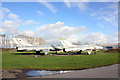
A pair of MiGs at Hawarden Airport
Two static MiG-21 fighters on display at Aviation Park, Hawarden Airport.
Image: © Jeff Buck
Taken: 9 Feb 2016
0.04 miles
3
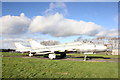
MiG-21 at Hawarden Airport
Static MiG-21 fighters on display at Aviation Park, Hawarden Airport.
Image: © Jeff Buck
Taken: 9 Feb 2016
0.04 miles
4
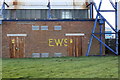
Emergency Water Supply Sign (EWS), Hawarden Airport
An EWS (Emergency Water Supply) sign on the side of an electricity sub-station at Aviation Park, Hawarden Airport. This appears to be quite a bright example (possibly retouched?) despite the S being cut off by the sub-station door.
During World War II Emergency water supplies were laid in many towns and cities to provide a source of water for extinguishing fires and incendiary bombs, should the main supplies be damaged. Many forms of pipe were used, from 6-inch iron pipes laid along gutters, to concrete shuttered trenches and canvas pipes in a metal frame. The cross-section may have been round, rectangular or square.
The water ran through these pipes from swimming pools, industrial tanks, specially built temporary tanks and even bombed-out cellars. Dammed-off rivers and streams were also used. These "Static Water Supplies" were to be found all over the place. Sometimes an "SWS" sign turns up (Static Water Supply), rather than an "EWS".
*Thanks to Russell W. Barnes and the 'Defence of Cumbria in the 20th Century' web page for the information.
Image: © Jeff Buck
Taken: 9 Feb 2016
0.05 miles
5
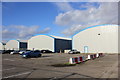
Hangar at Hawarden Airport
BAE's Airbus factory
Image: © Chris Morgan
Taken: 30 Apr 2022
0.05 miles
7
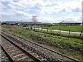
View from a Chester-Holyhead train - The Beeches industrial estate
Image: © Nigel Thompson
Taken: 2 May 2018
0.07 miles
8
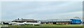
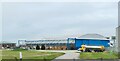
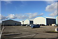
Buildings at Aviation Park, Hawarden Airport
Hangar style buildings being used by numerous independent businesses at Aviation Park, Hawarden Airport.
Image: © Jeff Buck
Taken: 9 Feb 2016
0.10 miles
9
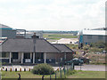
Buildings at Aviation Park, Hawarden Airport
Hangars now being used by numerous independent businesses at Aviation Park. The building on the left is the Chocks Away diner.
Image: © Jeff Buck
Taken: 9 Feb 2016
0.11 miles
10
Hawarden Airport
Beyond the former RAF Guardroom is the Airfield previously used by the Royal Air Force and now part of the huge Aircraft factory complex.
Image: © Dennis Turner
Taken: 30 Aug 2005
0.14 miles