IMAGES TAKEN NEAR TO
Old Mill Place, CHESTER, CH3 9RJ
Introduction
This page details the photographs taken nearby to Old Mill Place, CH3 9RJ by members of the Geograph project.
The Geograph project started in 2005 with the aim of publishing, organising and preserving representative images for every square kilometre of Great Britain, Ireland and the Isle of Man.

There are currently over 7.5m images from over14,400 individuals and you can help contribute to the project by visiting https://www.geograph.org.uk
Image Map
Images are licensed for reuse under creativecommons.org/licenses/by-sa/2.0
Notes
- Clicking on the map will re-center to the selected point.
- The higher the marker number, the further away the image location is from the centre of the postcode.
Image Listing (23 Images Found)
Images are licensed for reuse under creativecommons.org/licenses/by-sa/2.0
Image
Details
Distance
1
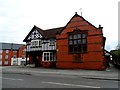
The Barbour Institute, Tattenhall
Functions as a village hall. Presumably the "Barbour" name is that of the local family who own Bolesworth Castle and much of the land around here.
Image: © Bikeboy
Taken: 10 Apr 2014
0.03 miles

4
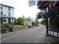
Entrance to Tattenhall Hall
Tattenhall was built in the early C17. In 1856 it was bought Robert Barbour. The walls and these gates were designed by Thomas Harrison (see http://en.wikipedia.org/wiki/List_of_works_by_Thomas_Harrison ) and built around 1858.
Image: © Bikeboy
Taken: 10 Apr 2014
0.10 miles
6
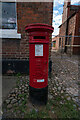
Edward VII (1901-1910) Post Box, Tattenhall
Image: © Brian Deegan
Taken: 10 Sep 2022
0.11 miles
7
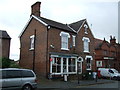
Tattenhall Post Office
Showing position of Postbox No. CH3 223.
See Image] for postbox.
Image: © JThomas
Taken: 12 Nov 2016
0.12 miles
8

Edward VII postbox, Tattenhall Post Office
Postbox No. CH3 223.
See Image] for context.
Image: © JThomas
Taken: 12 Nov 2016
0.12 miles
9
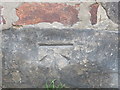
Ordnance Survey Cut Mark
This can be found on the roadside wall of a building in High Street, Tattenhall.
For more detail see : http://www.bench-marks.org.uk/bm80590
Image: © Peter Wood
Taken: 2 Dec 2016
0.12 miles
10
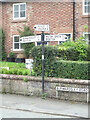
Fingerpost, Tattenhall
Opposite Chester Rd. Old style direction plates, with a detent ring to fix the position of the fingers.
Inscription: Huxley 3 / Chester 8 // Burwardsley 2½ / Beeston 4 // Milton Green 2 / Broxton 3
Milestone Society National ID: CH_SJ4858A
Image: © Mr Red
Taken: 26 Aug 2021
0.13 miles